Deer River, Minnesota
| Deer River, Minnesota | |
|---|---|
| City | |
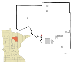
 Location of the city of Deer River within Itasca County, Minnesota |
|
| Coordinates: 47°20′6″N 93°47′39″W / 47.33500°N 93.79417°W | |
| Country | United States |
| State | Minnesota |
| County | Itasca |
| Area | |
| • Total | 1.29 sq mi (3.34 km2) |
| • Land | 1.29 sq mi (3.34 km2) |
| • Water | 0 sq mi (0 km2) |
| Elevation | 1,293 ft (394 m) |
| Population (2010) | |
| • Total | 930 |
| • Estimate (2012) | 929 |
| • Density | 720.9/sq mi (278.3/km2) |
| Time zone | Central (CST) (UTC-6) |
| • Summer (DST) | CDT (UTC-5) |
| ZIP code | 56636 |
| Area code(s) | 218 |
| FIPS code | 27-15310 |
| GNIS feature ID | 0655967 |
| Website | http://www.deerrivercity.com/ |
Deer River is a city in Itasca County, Minnesota, United States. The population was 930 at the 2010 census.
U.S. Highway 2 and Minnesota State Highways 6 and 46 are three of the main routes in the community.
Deer River is home to the world's largest Wild Rice Festival. Possibly its greatest attribute is its proximity to several beautiful lakes, including Deer Lake, Bowstring Lake, Leech Lake, and Lake Winnibigoshish.
Deer River has a site on the National Register of Historic Places, the Itasca Lumber Company Superintendent's House, built in 1904 by the leading lumber company in the area.
Late in World War II, a logging camp manned by prisoners of war was located at the site of an old CCC camp near Deer River.
According to the United States Census Bureau, the city has a total area of 1.29 square miles (3.34 km2), all of it land.
As of the census of 2010, there were 930 people, 397 households, and 212 families residing in the city. The population density was 720.9 inhabitants per square mile (278.3/km2). There were 434 housing units at an average density of 336.4 per square mile (129.9/km2). The racial makeup of the city was 83.8% White, 0.1% African American, 11.5% Native American, 0.1% from other races, and 4.5% from two or more races. Hispanic or Latino of any race were 0.3% of the population.
...
Wikipedia
