Deer Park, California
| Deer Park | |
|---|---|
| census-designated place | |
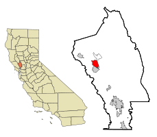
 Location in Napa County and the state of California |
|
| Location in the United States | |
| Coordinates: 38°32′14″N 122°28′21″W / 38.53722°N 122.47250°W | |
| Country |
|
| State |
|
| County | Napa |
| Area | |
| • Total | 5.582 sq mi (14.458 km2) |
| • Land | 5.578 sq mi (14.448 km2) |
| • Water | 0.004 sq mi (0.009 km2) 0.07% |
| Elevation | 568 ft (173 m) |
| Population (2010) | |
| • Total | 1,267 |
| • Density | 230/sq mi (88/km2) |
| Time zone | Pacific (PST) (UTC-8) |
| • Summer (DST) | PDT (UTC-7) |
| ZIP code | 94576 |
| Area code(s) | 707 |
| FIPS code | 06-18324 |
| GNIS feature IDs | 1867011; 2408647 |
| U.S. Geological Survey Geographic Names Information System: Deer Park, California; U.S. Geological Survey Geographic Names Information System: Deer Park, California | |
Deer Park is a census-designated place (CDP) in Napa County, California, United States. The population was 1,267 at the 2010 census. It is part of the Napa, California Metropolitan Statistical Area. Its area code is 707. Its zip code is 94576. It is in the Pacific time zone. Perhaps its best-known attraction is Elmshaven, a large Victorian home lived in by Ellen White in the early twentieth century.
Deer Park is located at 38°32′14″N 122°28′21″W / 38.53722°N 122.47250°WCoordinates: 38°32′14″N 122°28′21″W / 38.53722°N 122.47250°W (38.537257, -122.472386).
According to the United States Census Bureau, the CDP has a total area of 5.6 square miles (15 km2), 99.93% of it land and 0.07% of it water.
...
Wikipedia

