Deale, Maryland
| Deale, Maryland | |
|---|---|
| Census-designated place | |

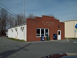
The U.S. Post Office in Deale, Maryland, in March 2010
|
|
 Location of Deale, Maryland |
|
| Coordinates: 38°47′30″N 76°32′20″W / 38.79167°N 76.53889°WCoordinates: 38°47′30″N 76°32′20″W / 38.79167°N 76.53889°W | |
| Country | |
| State |
|
| County |
|
| Area | |
| • Total | 5.9 sq mi (15.4 km2) |
| • Land | 5.3 sq mi (13.7 km2) |
| • Water | 0.7 sq mi (1.7 km2) |
| Elevation | 7 ft (2 m) |
| Population (2010) | |
| • Total | 4,945 |
| • Density | 936/sq mi (361.2/km2) |
| Time zone | Eastern (EST) (UTC-5) |
| • Summer (DST) | EDT (UTC-4) |
| ZIP code | 20751 |
| Area code(s) | 410 |
| FIPS code | 24-22050 |
| GNIS feature ID | 0590075 |
Deale is a census-designated place (CDP) in Anne Arundel County, Maryland, United States. The population was 4,945 at the 2010 census. It has a scenic view of Chesapeake Bay and is popular with boaters. Sudley was listed on the National Register of Historic Places in 1973.
Deale is located at 38°47′30″N 76°32′20″W / 38.79167°N 76.53889°W (38.791766, -76.538933).
According to the United States Census Bureau, the CDP has a total area of 5.9 square miles (15.4 km2), of which 5.3 square miles (13.7 km2) is land and 0.66 square miles (1.7 km2), or 11.01%, is water.
Deale is a waterfront fishing village located on the Western Shore of Chesapeake Bay. Four tidal creeks are located in Deale that flow into the bay: Rockhold Creek, Parker Creek, Carrs Creek, and Broadwater Creek. Rockhold Creek is the most commercial of the creeks and is home to several marinas and most of the charter fishing boats. Happy Harbor Restaurant, one of Deale's most famous landmarks, is located on Rockhold Creek.
As of the census of 2010, there were 4,945 people, 1,778 households, and 1,313 families residing in the CDP. The population density was 1,105.0 people per square mile (426.7/km²). There were 1,942 housing units at an average density of 447.4/sq mi (172.8/km²). The racial makeup of the CDP was 91.89% White, 6.01% African American, 0.10% Native American, 0.44% Asian, 0.06% Pacific Islander, 0.15% from other races, and 1.36% from two or more races. Hispanic or Latino of any race were 1.06% of the population.
...
Wikipedia
