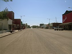
De Smet, South Dakota
| De Smet, South Dakota | |
|---|---|
| City | |

Downtown De Smet, South Dakota
|
|
 Location in Kingsbury County and the state of South Dakota |
|
| Coordinates: 44°23′9″N 97°33′6″W / 44.38583°N 97.55167°WCoordinates: 44°23′9″N 97°33′6″W / 44.38583°N 97.55167°W | |
| Country | United States |
| State | South Dakota |
| County | Kingsbury |
| Founded | 1880 |
| Incorporated | 1883 |
| Area | |
| • Total | 1.16 sq mi (3.00 km2) |
| • Land | 1.16 sq mi (3.00 km2) |
| • Water | 0 sq mi (0 km2) |
| Elevation | 1,726 ft (526 m) |
| Population (2010) | |
| • Total | 1,089 |
| • Estimate (2015) | 1,072 |
| • Density | 938.8/sq mi (362.5/km2) |
| Time zone | Central (CST) (UTC-6) |
| • Summer (DST) | CDT (UTC-5) |
| ZIP code | 57231 |
| Area code(s) | 605 |
| FIPS code | 46-16260 |
| GNIS feature ID | 1265178 |
| Website | http://www.desmetsd.com/ |
De Smet is a city in and the county seat of Kingsbury County, South Dakota, United States. The population was 1,089 at the 2010 census.
Located in the area of South Dakota known as East River (east of the Missouri River, which diagonally divides the state), De Smet was platted by European Americans in 1880. It was named for Belgian Father Pierre De Smet, a 19th-century Jesuit missionary who worked with Native Americans in the United States and its territories for most of his life. In the mid 1880s, prairie fires and failures of crops after a three-year period of drought caused many settlers to relocate their farms and homesteads to easier areas. By 1917, De Smet was a cow town, with many trains passing through every day carrying cattle to market.
De Smet is located at 44°23′9″N 97°33′6″W / 44.38583°N 97.55167°W (44.385871, -97.551703).
According to the United States Census Bureau, the city has a total area of 1.16 square miles (3.00 km2), all of it land.
De Smet has been assigned the ZIP code 57231 and the FIPS place code 16260.
...
Wikipedia
