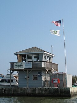
Davis Park
| Davis Park | |
|---|---|
| Hamlet | |

Davis Park Dockmaster Tower, Ferry Port and Marina
|
|
| Location within the state of New York | |
| Coordinates: 40°41′0″N 73°1′30″W / 40.68333°N 73.02500°WCoordinates: 40°41′0″N 73°1′30″W / 40.68333°N 73.02500°W | |
| Country | United States |
| State | New York |
| County | Suffolk |
| Time zone | Eastern (EST) (UTC-5) |
| • Summer (DST) | EDT (UTC-4) |
| ZIP codes | 11772 |
| GNIS feature ID | 948069 |
Davis Park is a hamlet on Fire Island in the Town of Brookhaven in Suffolk County, in the U.S. state of New York, off the South Shore village of Patchogue, Long Island. It lies within the Fire Island National Seashore. Davis Park is commonly used to refer to the business and public part of the community on both sides of Trustees' Walk, in contrast to the sections known as Leja Beach (to the west of Trustees Walk bounding Center Walk to the North and South) and Ocean Ridge (to the east). However, Davis Park is also used to refer to all three areas together, which are contiguous, share services and social life, and are separated from other communities on the island.
Davis Park/Leja Beach/Ocean Ridge is the eastern-most private community on Fire Island. (Formerly, there were other communities to the east that were removed by the National Park Service after the creation of Fire Island National Seashore in 1964. They included Bayberry Dunes, Whalehouse Point and Long Cove.)
The community extends along approximately 3/4 mile (1.25 km) of beachfront, and is approximately 330 yards (0.3 km) wide at its widest and 190 yards (0.17 km) wide at its narrowest point (dune to bay, excluding ocean beach width). Davis Park is bordered by extensive wilderness areas to both east and west. The Watch Hill facility of the National Park Service (with a small marina, restaurant, campground, nature trail and seasonal tours and activities) is approximately 1/2 mile (0.8 km) east, and Water Island (a community, not a separate island) is approximately one mile (1.6 km) to the west. Davis Park lies approximately 13.9 miles (22.3 km) from the eastern end of Fire Island at Moriches Inlet and 16.3 miles (26.3 km) from the western end of Fire Island at Democrat Point (in Robert Moses State Park).
...
Wikipedia

