Dartmouth, Nova Scotia (former city)
| Dartmouth | |
|---|---|
| Urban Community | |

Dartmouth waterfront, showing Alderney Landing, Halifax ferry and boats in the marina.
|
|
| Nickname(s): City of Lakes, "The Darkside" | |
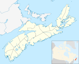
 Location of Dartmouth, shown in red |
|
| Location of Dartmouth, Nova Scotia | |
| Coordinates: 44°40′0″N 63°34′0″W / 44.66667°N 63.56667°WCoordinates: 44°40′0″N 63°34′0″W / 44.66667°N 63.56667°W | |
| Country |
|
| Province |
|
| Municipality | Halifax |
| Founded | 1750 |
| Incorporated City | January 1, 1961 |
| Amalgamated with Halifax | April 1, 1996 |
| Neighbourhoods | Albro Lake, Bell Ayr Park, Brightwood, Burnside, Commodore Park, Crichton Park, Crystal Heights, Downtown Dartmouth, Ellenvale, Grahams Corner, Greenough Settlement, Harbourview, Highfield Park, Imperoyal, Manor Park, Nantucket, Port Wallace, Portland Estates, Portland Hills, Shannon Park, Southdale, Tam O'Shanter Ridge, Tufts Cove, Wallace Heights, Woodlawn, Woodside |
| Government | |
| • Governing Body | Halifax Regional Council |
| • Community Council | Harbour East - Marine Drive Community Council |
| • Districts | 3 - Dartmouth South - Eastern Passage. 5 - Dartmouth Centre. 6 - Harbourview - Burnside - Dartmouth East |
| Area | |
| • Total | 58.57 km2 (22.61 sq mi) |
| Highest elevation | 113 m (371 ft) |
| Lowest elevation | 0 m (0 ft) |
| Population (2011) | |
| • Total | 67,573 |
| • Density | 1,153.71/km2 (2,988.1/sq mi) |
| Demonym(s) | Dartmouthian |
| Time zone | AST (UTC-4) |
| • Summer (DST) | ADT (UTC-3) |
| Postal code span | B2V to B2Z, B3A-B |
| Area code(s) | 902 |
| Telephone Exchanges | 433-5, 460-6, 468-9, 481 |
| GNBC Code | CAIYJ |
| NTS Map | 011D12 |
|
Part of a series about Places in Nova Scotia
|
|
Dartmouth is a community and former city in the Halifax Regional Municipality of Nova Scotia, Canada. Dartmouth is located on the eastern shore of Halifax Harbour. Dartmouth has been nicknamed the City of Lakes, after the large number of lakes located within its boundaries.
On April 1, 1996, the provincial government amalgamated all the municipalities within the boundaries of Halifax County into a single-tier regional government named the Halifax Regional Municipality (HRM). Dartmouth and its neighbouring city of Halifax, the town of Bedford and the Municipality of the County of Halifax were dissolved. The city of Dartmouth forms part of the urban core of the larger regional municipality and is officially designated as part of the "capital district" by the Halifax Regional Municipality. At the time that the City of Dartmouth was dissolved, the provincial government altered its status to a separate community to Halifax; however, its status as part of the metropolitan "Halifax" urban core existed prior to municipal reorganization in 1996.
Dartmouth is still an official geographic name that is used by all levels of government for legal purposes, postal service, mapping, 9-1-1 emergency response, municipal planning, and is recognized by the Halifax Regional Municipality as a civic addressing community. The official place name did not change, due to the confusion with similar street names, land use planning set out by the former "City of Dartmouth," and significant public pressure. Today the same development planning for Downtown Dartmouth and the rest of the region is still in force, as well as specific bylaws created prior to April 1, 1996.
Father Le Loutre's War began when Edward Cornwallis arrived to establish Halifax with 13 transports on June 21, 1749. By unilaterally establishing Halifax, the British were violating earlier treaties with the Mi'kmaq (1726), which were signed after Father Rale's War. The British quickly began to build other settlements. To guard against Mi'kmaq, Acadian and French attacks on the new Protestant settlements, British fortifications were erected in Halifax (1749), Dartmouth (1750), Bedford (Fort Sackville) (1751), Lunenburg (1753) and Lawrencetown (1754).
...
Wikipedia

