Darby Township, Delaware County, Pennsylvania
| Darby Township | |
|---|---|
| First Class Township | |

Darby Township Municipal Building in Darby Township, PA
|
|
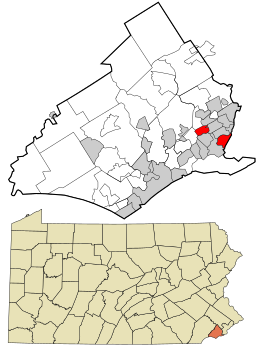
 Location in Delaware County and the state of Pennsylvania. |
|
 Location of Pennsylvania in the United States |
|
| Coordinates: 39°54′00″N 75°17′29″W / 39.90000°N 75.29139°WCoordinates: 39°54′00″N 75°17′29″W / 39.90000°N 75.29139°W | |
| Country | United States |
| State | Pennsylvania |
| County | Delaware |
| Settled | 1682 |
| Area | |
| • Total | 1.4 sq mi (4 km2) |
| • Land | 1.4 sq mi (4 km2) |
| • Water | 0.0 sq mi (0 km2) |
| Elevation | 89 ft (27 m) |
| Population (2010) | |
| • Total | 9,264 |
| • Estimate (2016) | 9,297 |
| • Density | 6,617.1/sq mi (2,554.9/km2) |
| Time zone | EST (UTC-5) |
| • Summer (DST) | EDT (UTC-4) |
| Area code(s) | 610 |
| FIPS code | 42-045-18160 |
| Website | www |
Darby Township is a township in Delaware County, Pennsylvania, United States. The population was 9,264 as of the 2010 census. It is home to both residential areas and expansive industrial districts. Darby Township is home to a diverse population and its industrial districts are popular among shipping companies for its proximity to Philadelphia International Airport. It also is known for being made up of two non-contiguous geographical areas, requiring one to pass through at least two neighboring municipalities to make it from one end of Darby Township to the other. Darby Township is a distinct municipality from the nearby and similarly named Darby Borough and Upper Darby Township.
The area, now known as Darby Township, was settled almost immediately after the coming of William Penn (1682), and in 1683 was recognized as one of the localities where a permanent lodgement had been made but despite that fact, it is believed that the population was sparse for more than a quarter of a century. In 1684 Darby Friends’ Meeting had been established. In the same year the first official record of Darby occurs in the list of collectors “to gather the assessment for the building of the court-house.” Thomas Worth and Joshua Fearne were appointed to those offices for Darby, and Mons Stacker and William Cobb “for Amosland & Calcoone Hook.” The latter was recognized as a distinct municipal district until 1686, when Calcoone Hook was made a part of Darby Township, and Amosland was annexed to Ridley. Calcon or Calkoen's Hook comprised all the territory between Cobb's Creek on the east, and the Mokormpates Kill or Muckinipattas Creek on the west, and derives its name from the Swedish word Kalkon (a turkey) and Walda Kalkoen (wild turkeys). Later the territory known by that name became restricted to that part lying south of the Philadelphia, Wilmington, and Baltimore Railroad, while its eastern boundary was Morhorhootink, as shown in the atlas of the early grants in Delaware County.
...
Wikipedia
