Daniels County, Montana
| Daniels County, Montana | |
|---|---|

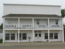
Daniels County Courthouse in Scobey
|
|
 Location in the U.S. state of Montana |
|
 Montana's location in the U.S. |
|
| Founded | 1920 |
| Seat | Scobey |
| Largest city | Scobey |
| Area | |
| • Total | 1,426 sq mi (3,693 km2) |
| • Land | 1,426 sq mi (3,693 km2) |
| • Water | 0.4 sq mi (1 km2), 0.03% |
| Population (est.) | |
| • (2015) | 1,760 |
| • Density | 1.2/sq mi (0/km²) |
| Congressional district | At-large |
| Time zone | Mountain: UTC-7/-6 |
Daniels County is a county located in the U.S. state of Montana. As of the 2010 census, the population was 1,751. Its county seat is Scobey.
As of 2000, Daniels County was considered the most rural county in the continental United States as measured by the Index of Relative Rurality. It is south of the Canada–US border with Saskatchewan.
Daniels County was created in 1920 from portions of Sheridan and Valley Counties. The name comes from Mansfield Daniels, a local rancher.
According to the U.S. Census Bureau, the county has a total area of 1,426 square miles (3,690 km2), of which 1,426 square miles (3,690 km2) is land and 0.4 square miles (1.0 km2) (0.03%) is water.
Daniels County is predominately rolling plains. The Poplar River flows through the county.
As of the census of 2000, there were 2,017 people, 892 households, and 561 families residing in the county. The population density was 1.4 people per square mile (0.55/km²). There were 1,154 housing units at an average density of 1 per square mile (0/km²). The racial makeup of the county was 96.03% White, 1.29% Native American, 0.25% Asian, 0.10% Pacific Islander, 0.59% from other races, and 1.74% from two or more races. 1.59% of the population were Hispanic or Latino of any race. 35.7% were of Norwegian, 20.0% German, 7.8% Irish and 5.5% French ancestry.
...
Wikipedia
