Dallas Township, Pennsylvania
| Dallas Township, Pennsylvania | |
|---|---|
| Township | |

Scenery of Dallas Township from Lower Demunds Road
|
|
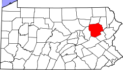
 Map of Luzerne County, Pennsylvania Highlighting Dallas Township |
|
 Map of Luzerne County, Pennsylvania |
|
| Country | United States |
| State | Pennsylvania |
| County | Luzerne |
| Area | |
| • Total | 18.7 sq mi (48.5 km2) |
| • Land | 18.5 sq mi (48.0 km2) |
| • Water | 0.2 sq mi (0.5 km2) |
| Population (2010) | |
| • Total | 8,994 |
| • Density | 480/sq mi (190/km2) |
| Time zone | Eastern (EST) (UTC-5) |
| • Summer (DST) | EDT (UTC-4) |
| Website | www |
Dallas Township is a township in Luzerne County, Pennsylvania, United States. The population was 8,994 at the 2010 census. The township was formed in 1817 from territory taken from Kingston Township, and it was named for Alexander J. Dallas, who was the 6th United States Secretary of the Treasury and also the father of George M. Dallas, the vice president of James Polk.
According to the United States Census Bureau, the township has a total area of 18.7 square miles (48.5 km2), of which 18.5 square miles (48.0 km2) is land and 0.19 square miles (0.5 km2), or 1.09%, is water.
As of the census of 2000, there were 8,179 people, 2,917 households, and 2,047 families residing in the township. The population density was 436.7 people per square mile (168.6/km2). There were 3,125 housing units at an average density of 166.9/sq mi (64.4/km2). The racial makeup of the township was 98.45% White, 0.21% African American, 0.06% Native American, 0.72% Asian, 0.01% Pacific Islander, 0.13% from other races, and 0.42% from two or more races. Hispanic or Latino of any race were 0.56% of the population.
...
Wikipedia
