Dales Way
| Dales Way | |
|---|---|

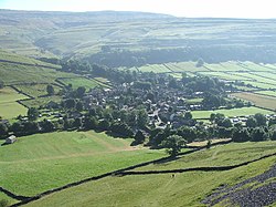
Kettlewell lies on the trail
|
|
| Length | 135 km (84 mi) |
| Location | Northern England |
| Trailheads |
Ilkley, Yorkshire Bowness-on-Windermere, Cumbria |
| Use | Hiking |
| Elevation | |
| Highest point | Cam Houses, 490 m (1,610 ft) |
The Dales Way is an 84-mile (135 km) long-distance footpath in Northern England, from (south-east to north-west) Ilkley, West Yorkshire, to Bowness-on-Windermere, Cumbria. This walk was initially devised by the West Riding Ramblers' Association with the 'leading lights' being Colin Speakman and Tom Wilcock (Foootpath Secretary). The route was announced to the public in 1968 and the first recorded crossing was by a group of Bradford Grammar School Venture Scouts in 1969.
The Dales Way passes through two National Parks: the Yorkshire Dales National Park and the Lake District National Park. The first half of the walk follows the River Wharfe upstream to the main watershed of northern England at Ribblehead. The second half follows several river valleys (Dentdale, River Mint, River Kent) to descend to the shores of Windermere.
The walk is shorter and less strenuous than more well-known routes such as the Pennine Way and Coast to Coast Walk, being mostly along river valleys. It thus makes a good introductory training ground for these "serious" walks while being well worth doing in its own right. The section from upper Wharfedale (Langstrothdale) over the watershed at Cam Houses and down into Ribblesdale is steep (going up and down).
It is feasible (for those more interested in a challenge than the enjoyment of the walk) to complete the walk the route in around four days, but most walkers take about a week, dividing the route into sections of 10 to 15 miles per day and taking a "rest day" or two.
...
Wikipedia
