Daisetsuzan Volcanic Group
| Daisetsuzan Volcanic Group | |
|---|---|
| Nutapukaushipe or Nutaku Kamushupe | |

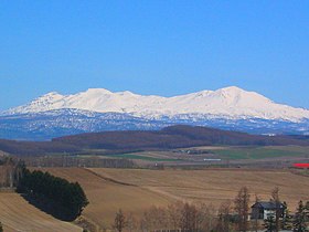
A view from Biei town
|
|
| Highest point | |
| Peak | Mount Asahi |
| Elevation | 2,290 m (7,510 ft) |
| Coordinates | 43°39′N 142°51′E / 43.650°N 142.850°ECoordinates: 43°39′N 142°51′E / 43.650°N 142.850°E |
| Naming | |
| Etymology | big snowy mountains |
| Native name | 大雪山系 Daisetsu-zankei |
| Geography | |
| Country | Japan |
| State | Hokkaidō |
| Region | Kamikawa subprefecture |
| Parent range | Ishikari Mountains |
| Biome | alpine climate |
| Geology | |
| Orogeny | island arc |
| Age of rock | Quaternary |
| Type of rock | volcanic |
| Last eruption | AD 1739 or later |
The Daisetsuzan Volcanic Group (大雪山系 Daisetsu-zankei?, also called Taisetsu-zan) is a volcanic group of peaks arranged around the 2 kilometres (1.2 mi) wide Ohachi-Daira (御鉢平 Ohachi-daira?) caldera in Hokkaidō, Japan. In the Ainu language it is known as Nutapukaushipe or Nutaku Kamushupe. These peaks are the highest in Hokkaidō. The group lends its name to the Daisetsuzan National Park in which the volcanic group is located.
The volcanic group lies at the north end of the Daisetsu-Tokachi graben on the Kurile arc of the Pacific ring of fire. The volcanic zone makes itself known through a number of fumaroles and natural hot springs.
The following peaks make up the volcanic group:
...
Wikipedia
