Daingean
|
Daingean an Daingean
|
|
|---|---|
| Town | |

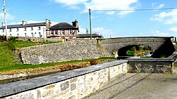
Molesworth Bridge, Daingean as seen from the Harbour
|
|
| Location in Ireland | |
| Coordinates: 53°17′42″N 7°17′31″W / 53.295°N 7.292°WCoordinates: 53°17′42″N 7°17′31″W / 53.295°N 7.292°W | |
| Country | Ireland |
| Province | Leinster |
| County | Offaly |
| Government | |
| • Dáil Éireann | Laois-Offaly |
| Elevation | 78 m (256 ft) |
| Population (2011) | |
| • Urban | 1,037 |
| • Rural | 391 |
| Time zone | WET (UTC+0) |
| • Summer (DST) | IST (WEST) (UTC-1) |
| Area code(s) | 057 |
| Irish Grid Reference | N474275 |
| Website | [1] |
Daingean (/ˈdæŋɡən/; Irish: An Daingean, meaning "the fort" or Daingean Ua bhFáilghe), formerly Philipstown, is a small town in east County Offaly, Ireland. It is situated midway between the towns of Tullamore and Edenderry on the R402 regional road. The town or townland of Daingean has a population (2002) of 777 while the District Electoral Division (DED) has a total population of 1168. It is the principal town of the Daingean Catholic Parish. The other main poles of this parish are Ballycommon, Kilclonfert and Cappincur.
Daingean was originally named Philipstown in 1556 when it was established as the county town in the land that was planted by Queen Mary I in the newly shired King’s County. The town and the county was so named after her husband and co-monarch, King Philip.
The town was once the seat of the O’Connor clan, who were chieftains of the surrounding area of Offaly. Its current name ‘Daingean’ from Daingean Ua bhFáilghe means fortress of the Uí Fáilghe clan, a name that it derived from the medieval island fortress of O'Connor Faly. In 1883 Tullamore replaced Daingean as the focal point of the county. As a result, Philipstown was demoted from capital town to village and as a result lost most of its political status. It was in 1922, with the foundation of the Free State, that the village was renamed Daingean, at the same time as County Offaly replaced the old King's County.
...
Wikipedia

