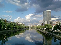
Dâmboviţa River
| Râul Dâmbovița | |
| River | |
|
The Dâmbovița River in Bucharest
|
|
| Countries | Romania |
|---|---|
| Counties | Argeș, Dâmbovița, Ilfov, Bucharest, Călărași |
| Tributaries | |
| - left | Colentina, Ilfov |
| Cities | Bucharest |
| Source | Curmătura Oticu |
| - location | Făgăraș Mountains |
| - elevation | 1,800 m (5,906 ft) |
| - coordinates | 45°29′54″N 24°56′14″E / 45.49833°N 24.93722°E |
| Mouth | Argeș River |
| - location | Budești |
| - elevation | 43 m (141 ft) |
| - coordinates | 44°13′40″N 26°28′16″E / 44.22778°N 26.47111°ECoordinates: 44°13′40″N 26°28′16″E / 44.22778°N 26.47111°E |
| Length | 286 km (178 mi) |
| Official River Code Progression |
X.1.25 Argeș→ Danube→ Black Sea |
Dâmbovița (Romanian pronunciation: [ˈdɨmbovit͡sa]) is a river in Romania. It has its sources in the Făgăraș Mountains, on the Curmătura Oticu. The upper reach of the rivers, upstream of the confluence with the Boarcășu River is also known as Izvorul Oticului River or Oticu River.
It passes through Bucharest and flows into the Argeș River 286 kilometres from its source, near Budești, in Călărași County. Dâmbovița County is named after the river.
The name of the Dâmbovița is of Slavic origin, derived from Common Slavic dŭbŭ (дъбъ), (дѫбъ), meaning "oak", as it once flowed through the oak forests of the Wallachian Plain.
For centuries, Dâmbovița was the main source of drinking water for the city of Bucharest. While there were a few dozen water wells, most of the water in Bucharest was distributed by water-carriers.
Bucharest folkore mentions the waters of Dâmbovița as "sweet", and even at the beginning of the 18th century, Anton Maria del Chiaro considered it "light and clean". However, toward the end of the 18th century, as the population of Bucharest increased, the river ceased to be as clean, and hence the need of the aqueducts. The earliest aqueducts with public fountains (cișmele) were built during the rule of Prince Alexander Ypsilantis.
Many watermills were built on the Dâmbovița, most of them owned by the prince, the monasteries or boyars.
...
Wikipedia

