Cyril E. King Airport
| Cyril E. King Airport | |||||||||||
|---|---|---|---|---|---|---|---|---|---|---|---|
 |
|||||||||||
| Summary | |||||||||||
| Airport type | Public | ||||||||||
| Owner | Virgin Islands Port Authority | ||||||||||
| Location | Saint Thomas, U.S. Virgin Islands | ||||||||||
| Focus city for | Air Sunshine | ||||||||||
| Elevation AMSL | 24 ft / 7 m | ||||||||||
| Coordinates | 18°20′14″N 064°58′24″W / 18.33722°N 64.97333°WCoordinates: 18°20′14″N 064°58′24″W / 18.33722°N 64.97333°W | ||||||||||
| Website | viport.com | ||||||||||
| Map | |||||||||||
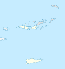
| Location in the Virgin Islands | |||||||||||
| Runways | |||||||||||
|
|||||||||||
| Statistics (2015) | |||||||||||
|
|||||||||||
|
Source: Federal Aviation Administration
|
|||||||||||
| Aircraft operations | 65,407 |
|---|---|
| Based aircraft | 98 |
Cyril E. King Airport (IATA: STT, ICAO: TIST, FAA LID: STT) is a public airport located two miles (3 km) west of the central business district of Charlotte Amalie on the island of St. Thomas in the United States Virgin Islands. It is currently the busiest airport in the United States Virgin Islands, and one of the busiest in the eastern Caribbean, servicing 1,403,000 passengers from July 2015 until June 2016. The airport also serves nearby St. John and is often used by those traveling to the British Virgin Islands.
Although passports are not required for U.S. citizens who are visiting the U.S. Virgin Islands, all passengers bound for the United States and Puerto Rico must pass through U.S. Customs and Border Protection screening before boarding their flight. Private planes can either use CBP Preclearance or arrive in the United States as an international arrival.
The airport operates one main runway, 7,000 ft × 150 ft (2,134 m × 46 m) long. The terminal operates 11 gates.
During World War II, the United States Army Air Forces Sixth Air Force 23rd Fighter Squadron (36th Fighter Group) deployed P-40 Warhawk fighters to the airport from March 1942 – May 1943.
...
Wikipedia

