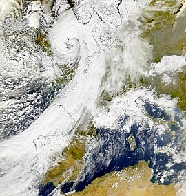
Cyclone Oratia

Oratia on 30 October
|
|
| Type |
European windstorm Extratropical cyclone |
|---|---|
| Formed | 28 October 2000 |
| Dissipated | 3 November 2000 |
| Lowest pressure | 941 mb (27.8 inHg) |
| Highest gust | 176 km/h (109 mph) in Camaret-sur-Mer, France |
| Areas affected | Western Europe |
Cyclone Oratia, (Tora in Norway) was an unusually deep European windstorm which affected Western Europe early in the year for a storm of this type. The storm was the fiercest to hit Britain in October since the Great Storm of 1987, with wind gusts reaching 109 mph, and gusting at up to 90 mph over much of the south of England. Its barometric pressure fell to 941 hPa, over the North Sea making it one of the deepest lows recorded in the country in October. The lowest land-based pressure observation reached 951.2 hPa at RAF Fylingdales, which is not lower than the UK record October value of 946.8 hPa observed at Cawdor Castle on 14 October 1981. Three tornadoes were reported from this storm. The storm contributed to the ongoing Autumn 2000 western Europe floods.
On 26 October, a deep low pressure centre anchored between Greenland and Iceland, trailing a cold front across the North Atlantic Ocean which spawned three strong storms. Cyclone Oratia developed in the Atlantic to the southwest of Ireland on 28 October during a strong 150 mph (240 km/h) upper level jet. The low explosively deepened, with a 53 mb (1.6 inHg) drop in pressure in 18 hours preceding 1800 UTC on 30 October. The centre of the low pressure passed south of Ireland, undergoing frontal fracture according to the Shapiro-Keyser model of cyclone development, and continued across North Wales and Northern England on a line approximately from Aberystwyth–Manchester–Teesside. The cyclone developed complex mesoscale features such as a sting jet, convective rainbands and inertial gravity waves. Strong winds affected areas on both sides of the English Channel with the worst winds since 1987. The storm produced sustained hurricane-force winds across the North Sea. Oratia began to fill as it approached Norway and was eventually absorbed by another cyclone.
...
Wikipedia
