Cut Bank, Montana
| Cut Bank, Montana | |
|---|---|
| City | |

Housing along Cut Bank Creek
|
|
 Location of Cut Bank, Montana |
|
| Coordinates: 48°38′5″N 112°19′52″W / 48.63472°N 112.33111°WCoordinates: 48°38′5″N 112°19′52″W / 48.63472°N 112.33111°W | |
| Country | United States |
| State | Montana |
| County | Glacier |
| Area | |
| • Total | 0.98 sq mi (2.55 km2) |
| • Land | 0.98 sq mi (2.55 km2) |
| • Water | 0 sq mi (0 km2) |
| Elevation | 3,773 ft (1,150 m) |
| Population (2010) | |
| • Total | 2,869 |
| • Estimate (2015) | 3,002 |
| • Density | 3,043/sq mi (1,175.0/km2) |
| Time zone | Mountain (MST) (UTC−7) |
| • Summer (DST) | MDT (UTC−6) |
| ZIP code | 59427 |
| Area code(s) | 406 |
| FIPS code | 30-18775 |
| GNIS feature ID | 0770395 |
| Website | cityofcutbank |
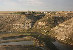
Cut Bank is a city in and the county seat of Glacier County, Montana, United States, located just east of the "cut bank" (gorge) along Cut Bank Creek. The population was 2,869 at the 2010 census, and the estimated population in 2015 was 3,002.
Cut Bank is located in eastern Glacier County at 48°38′5″N 112°19′52″W / 48.63472°N 112.33111°W (48.634801, −112.331090).U.S. Route 2 passes through the city as Main Street, leading east 22 miles (35 km) to Interstate 15 at Shelby and west 34 miles (55 km) to Browning. The Blackfeet Indian Reservation is located just west of Cut Bank, on the western side of Cut Bank Creek.
According to the United States Census Bureau, the city has a total area of 0.99 square miles (2.56 km2), all of it land.
The city is located 30 miles (48 km) south of the Canada–United States border. The name of the city comes from the cut bank (gorge) — a scenic hazard to navigation and a geologic feature of the same name. The Cut Bank Creek river is spanned cliffs to cliffs by a scenic elevated railway bridge high above the canyon floor less than a mile from the edge of the town.
...
Wikipedia
