Culiacan
|
Culiacán Rosales Culiacán |
||
|---|---|---|
|
||
| Nickname(s): La Perla del Humaya (The Pearl of the Humaya) |
||
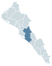
 Location of Culiacán within Sinaloa |
||
 Location of Sinaloa within Mexico |
||
| Coordinates: 24°48′17.46″N 107°23′07.79″W / 24.8048500°N 107.3854972°W | ||
| Country | Mexico | |
| State | Sinaloa | |
| Foundation | 1531 | |
| Government | ||
| • Mayor | Sergio Torres Felix |
|
| Area | ||
| • Total | 63 km2 (24 sq mi) | |
| Elevation | 71 m (233 ft) | |
| Population (2010) | ||
| • Total | 858,638 | |
| • Density | 136/km2 (350/sq mi) | |
| • Demonym | Culiacanense / "culichi" | |
| Time zone | MST (UTC−7) | |
| • Summer (DST) | MDT (UTC−6) | |
| Waterways | Tamazula River, Humaya River, Culiacán River | |
| Airports | Federal de Bachigualato International Airport | |
| Public transit | RedPlus | |
| Railroads | Ferromex Culiacán Station | |
| Website | www |
|
Culiacán (![]() kuljaˈkan ) is a city in northwestern Mexico. It is the largest city in and the capital of the state of Sinaloa. It is also the seat of Culiacán Municipality. There are 675,773 inhabitants in the city (census of 2010) and 858,638 in the municipality. While the municipality has a total area of 4,758 km2 (1,837 sq mi), the city itself is dense, at only 65 km2 (25 sq mi).
kuljaˈkan ) is a city in northwestern Mexico. It is the largest city in and the capital of the state of Sinaloa. It is also the seat of Culiacán Municipality. There are 675,773 inhabitants in the city (census of 2010) and 858,638 in the municipality. While the municipality has a total area of 4,758 km2 (1,837 sq mi), the city itself is dense, at only 65 km2 (25 sq mi).
The city is located in a valley at the confluence of the Tamazula and Humaya Rivers, where the two meet to form the Culiacán River, 55 m above sea level. It is in the center of the state, at about the same distance to the other urban centers of the state: Los Mochis to the north, Mazatlán to the south, and Altata at the west.
The most accepted translation would be Colhuacan "place of those who adore the crooked god Coltzin". Other translation may be that come from the word coahuacan, which can mean "palace of snakes". Before the Spaniards arrived from Europe, this site had been a small Indian settlement since 628 when Amerindians had first founded it.
The city existing today was founded in 1531 by the Spanish captain Nuño Beltrán de Guzmán and named San Miguel de Culiacán. In the same decade, it was the terminus of the long journey of Alvar Núñez Cabeza de Vaca and company among natives. Explorer Francisco Vásquez de Coronado set out from Culiacán to explore what is now the southwestern United States. Settlers from Europe came to Culiacán, and in the following centuries, Culiacán continued to be a quiet town. Only after the federal government built dams in the adjacent areas in the 1950s did agriculture explode and the city began to grow exponentially. Some of Mexico's largest agricultural conglomerates operate in the vast and fertile coastal plains. The agroindustrial economy continues to be the single largest contributor to the region's legal economy. While the vast majority of technical and skilled labor is educated locally, the once-seasonal field labor pool now experiences a yearly shortage of workers. International patterns of migration now draw laborers from deep within Mexico's south to the northern border states and into the United States.
...
Wikipedia

