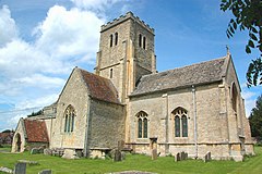
Cuddesdon
| Cuddesdon | |
|---|---|
 All Saints' parish church |
|
| Cuddesdon shown within Oxfordshire | |
| Population | 502 (parish, including Denton) (2001 census) |
| OS grid reference | SP6003 |
| Civil parish | |
| District | |
| Shire county | |
| Region | |
| Country | England |
| Sovereign state | United Kingdom |
| Post town | Oxford |
| Postcode district | OX44 |
| Dialling code | 01865 |
| Police | Thames Valley |
| Fire | Oxfordshire |
| Ambulance | South Central |
| EU Parliament | South East England |
| UK Parliament | |
| Website | Cuddesdon and Denton Community Website |
Cuddesdon is a mainly rural village in South Oxfordshire centred 5.5 miles (9 km) ESE of Oxford. It has the largest Church of England clergy training centre, Ripon College Cuddesdon.
Residents number approximately 430 in Cuddesdon's nucleated village centre and about 70 in the hamlets of Denton and Chippinghurst (2001 census).
Cuddesdon's toponym is derived from the Old English Cuddes Dune meaning "Cudde's Hill" or the "Hill of Cuthwine". When Oxfordshire was administered in hundreds, Cuddesdon parish was in the hundred of Bullingdon.
Cuddesdon was an Anglo-Saxon linear village along what is now High Street, but since the 19th century Church of England additions on the northern edge of the village and 20th century residential developments (principally Bishop's Wood and Parkside), it has become a nuclear settlement centred on The Green.
Since the 1950s many facilities and businesses in Cuddesdon, as in similar English villages, have closed, and most have been converted into housing for an increasingly commuter population. These include the petrol station, the shop, the school, the mill, the second public house and various farm buildings. Thus, the village has turned from a compact community into what is largely a dormitory village.
The parish is bounded by the River Thame to the east and southeast, its tributary Cuddesdon Brook to the north, by the road between Wheatley and Garsington to the west and by field boundaries to the southwest. The village is on a hill that overlooks south Oxfordshire, northern Berkshire, the Aylesbury Vale in central Buckinghamshire and a small part of west Bedfordshire. There are views of both the Chiltern Hills and the North Wessex Downs AONB stretching from Ivinghoe Beacon in the east to Didcot Power Station in the west.
...
Wikipedia

