Croydon, Pennsylvania
| Croydon | |
| Census-designated place | |
|
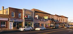
Downtown Croydon, Pennsylvania
|
|
| Country | United States |
|---|---|
| State | Pennsylvania |
| County | Bucks |
| Township | Bristol |
| Elevation | 20 ft (6.1 m) |
| Coordinates | 40°05′36″N 74°53′57″W / 40.09333°N 74.89917°WCoordinates: 40°05′36″N 74°53′57″W / 40.09333°N 74.89917°W |
| Area | 2.5 sq mi (6.5 km2) |
| - land | 2.5 sq mi (6 km2) |
| - water | 0.0 sq mi (0 km2), 0% |
| Population | 9,950 (2010) |
| Density | 3,980.0/sq mi (1,536.7/km2) |
| Timezone | EST (UTC-5) |
| - summer (DST) | EDT (UTC-4) |
| ZIP code | 19021 |
| Area code | 215 and 267 |
|
Location of Croydon in Bucks County
|
|
Croydon is a census-designated place located in Bucks County, Pennsylvania. As of the 2010 census, the CDP had a total population of 9,950.
The White Hall of Bristol College was listed on the National Register of Historic Places in 1984.
Croydon does not have a central government of its own. It is not organized or incorporated as a town or village. The area known as Croydon is located in Bristol Township. Croydon has an all-volunteer fire company which handles fire, medical, marine, and other calls servicing the community named Croydon Fire Company#1. Croydon uses zip code 19021.
Several notable mid-size businesses are headquartered in the business district of Croydon, including PAC Industries and Denaq Laptop Batteries. Neshaminy Creek Brewing Company is also located in Croydon.
Croydon is located at 40°5'36" North, 74°53'57" West (40.093443, -74.899128).
According to the United States Census Bureau, the CDP has a total area of 6.4 km2 (2.5 sq mi), all of it land. Croydon is bordered to the south by Neshaminy Creek, which is tidal, and navigable by small vessels (about a 8 ft (2.4 m) to 6 ft (1.8 m) draft at high tide). There are several private marinas on the Neshaminy, and a Commonwealth of Pennsylvania marina (part of Neshaminy State Park) at the mouth of the creek. The Neshaminy empties into the Delaware River, which borders Croydon to the east, and forms the boundary between Pennsylvania and New Jersey. The Delaware is tidal in Croydon, and is navigable by ocean-going vessels (40 foot marked / maintained channel) as far upriver as Trenton, New Jersey.
As of the 2010 census, Croydon was 82.9% White, 4.8% Black or African American, 0.2% Native American, 2.9% Asian, 0.1% some other race, and 1.6% were two or more races. 7.4% of the population was of Hispanic or Latino ancestry.[1]
...
Wikipedia


