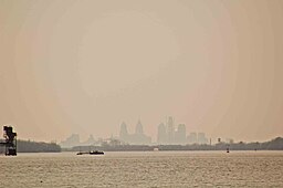
Neshaminy State Park
| Neshaminy State Park | |
| Pennsylvania State Park | |
|
The Philadelphia skyline as seen from Neshaminy State Park
|
|
| Country | United States |
|---|---|
| State | Pennsylvania |
| County | Bucks |
| Township | Bensalem |
| Location | |
| - elevation | 26 ft (8 m) |
| - coordinates | 40°04′42″N 74°55′59″W / 40.07833°N 74.93306°WCoordinates: 40°04′42″N 74°55′59″W / 40.07833°N 74.93306°W |
| Area | 330 acres (134 ha) |
| Founded | 1956 |
| Management | Pennsylvania Department of Conservation and Natural Resources |
| IUCN category | III - Natural Monument |
| Website: Neshaminy State Park | |
Neshaminy State Park is a 330-acre (134 ha) Pennsylvania state park in Bensalem Township, Bucks County, Pennsylvania in the United States. Visitors to the park can catch a glimpse of the Philadelphia skyline from a hiking trail on Logan Point. The park is located at the confluence of Neshaminy Creek and the Delaware River. Neshaminy State Park is just off Interstate 95 on Pennsylvania Route 132.
Most of the lands of Neshaminy State Park were donated to the Commonwealth of Pennsylvania by the estate of Robert R. Logan in 1956. Logan was a descendant of James Logan who was the colonial secretary to William Penn the founder of Pennsylvania. Dunks Ferry Road, which forms the western boundary of the park, is one of the oldest roads in Pennsylvania. It was built in 1679 by Dunken Williams to provide access to his ferry which crossed the Delaware River. Dunks Ferry Inn was a major rest stop that served travelers from the mid-18th until the late 19th century.
Neshaminy State Park is 116 miles (187 km) from the Atlantic Ocean, but it is at sea level. This combination of distance and elevation creates an estuary. The tidal affect causes the river to rise and fall each day. The Lenape who once lived on the banks of the river used tides to help them harvest fish. They built low fences in the tidal zone. At high tide the fish would swim in and be caught by the fences when the waters receded at low tide.
...
Wikipedia


