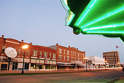
Crowley, Louisiana
| City of Crowley | |
| City | |
|
Downtown Crowley
|
|
| Motto: Where Life Is Rice And Easy | |
| Nickname: Rice Capital of America | |
| Country | United States |
|---|---|
| State | Louisiana |
| Parish | Acadia |
| Elevation | 20 ft (6.1 m) |
| Coordinates | 30°12′49″N 92°22′25″W / 30.21361°N 92.37361°WCoordinates: 30°12′49″N 92°22′25″W / 30.21361°N 92.37361°W |
| Area | 4.9 sq mi (12.7 km2) |
| - land | 4.9 sq mi (13 km2) |
| - water | 0.0 sq mi (0 km2), 0% |
| Population | 13,265 (2010) |
| Incorporated | 1887 |
| Mayor | Greg Jones Police Chief A. "Jimmy" Broussard (D) |
| Timezone | CST (UTC-6) |
| - summer (DST) | CDT (UTC-5) |
| ZIP code | 70526 |
| Area code | 337 |
|
Location of Louisiana in the United States
|
|
| Website: crowley-la.com | |
Police Chief A. "Jimmy" Broussard (D)
Crowley (Local pronunciation: /ˈkræli/) is a city in and the parish seat of Acadia Parish, Louisiana, United States. The population was 13,265 at the 2010 census but 14,225 in 2000, a loss of nearly a thousand persons. It is 63.8 percent Non-Hispanic White.
Crowley is noted for its annual International Rice Festival. Crowley has the nickname of "Rice Capital of America", because at one time it was a major center for rice harvesting and milling. Today, Crowley still has a number of rice mills and rice is the main crop of many local farmers. In addition, in recent years, crawfish farming has become increasingly popular.
The Crowley High School "Fighting Gents" were State Division 3A Champs in the 1989 football season and had an 8-2 regular season. Crowley is also the home of Notre Dame High School. Notre Dame is a parish-wide Catholic school whose football program has won 5 state championships and numerous District Champion titles.
Crowley is the principal city of the Crowley Micropolitan Statistical Area, which includes all of Acadia Parish. It is also part of the larger Lafayette–Acadiana Combined Statistical Area. The town is named after Pat Crowley.
Crowley is located at 30°12′49″N 92°22′25″W / 30.21361°N 92.37361°W (30.213618, -92.373695) and has an elevation of 20 feet (6.1 m).
...
Wikipedia


