Crow Agency
| Crow Agency, Montana | |
|---|---|
| CDP | |

Crow nation flag at Crow Agency
|
|
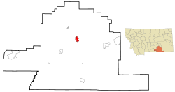
 Location of Crow Agency, Montana |
|
| Coordinates: 45°36′5″N 107°27′35″W / 45.60139°N 107.45972°WCoordinates: 45°36′5″N 107°27′35″W / 45.60139°N 107.45972°W | |
| Country | United States |
| State | Montana |
| County | Big Horn |
| Area | |
| • Total | 7.3 sq mi (18.8 km2) |
| • Land | 7.3 sq mi (18.8 km2) |
| • Water | 0.0 sq mi (0.0 km2) |
| Elevation | 3,038 ft (926 m) |
| Population (2010) | |
| • Total | 1,616 |
| • Density | 213.3/sq mi (82.3/km2) |
| Time zone | Mountain (MST) (UTC-7) |
| • Summer (DST) | MDT (UTC-6) |
| ZIP code | 59022 |
| Area code(s) | 406 |
| FIPS code | 30-18250 |
| GNIS feature ID | 0770332 |
Crow Agency is a census-designated place (CDP) in Big Horn County, Montana, United States and is near the actual location for the Little Bighorn National Monument and re-enactment produced by the Real Bird family known as Battle of the Little Bighorn Reenactment. The population was 1,616 at the 2010 census. It is the governmental headquarters of the Crow Native Americans. It is also the location of the "agency offices" where the federal Superintendent of the Crow Indian Reservation and his staff (part of the Bureau of Indian Affairs, United States Department of the Interior) interacts with the Crow Tribe, pursuant to federal treaties and statutes.
Crow Agency is located at 45°36′5″N 107°27′35″W / 45.60139°N 107.45972°W (45.601383, -107.459706).
According to the United States Census Bureau, the CDP has a total area of 7.3 square miles (19 km2), all of it land.
The term "Crow Agency" has been historically used since 1868 for the headquarters where the United States directed the federal interaction with the Crow tribe on its reservation. The Crow Tribe's reservations, and the tribe's relations to the United States were defined by treaties between the Crow Tribe and the United States, and by United States statutes.
The Treaty of Fort Laramie of 1851 created extensive reservation lands for the Indian tribes in Montana, Wyoming and the Dakotas at a time when the non-Indian presence in this area was limited to roving traders. A large reservation for the Crow Tribe was set out that was centered on the Big Horn Mountains and extended eastward into the Powder River basin to the banks of the Powder River. However, this treaty did not indicate agency sites for any of the tribes, including the Crows. At the time of the treaty, 1851 the Crow tribe consisted of nomadic bands whose culture was based on hunting the migratory buffalo herds, including those herds in the Powder River Country. Hunting in the Powder River area on the east side of the Big Horn Mountains brought the Crow in increasing conflict with more powerful bands of Sioux who were migrating westward. In 1863 gold was discovered in commercial quantities in the mountains of the western Montana Territory. Travelers to the gold fields left the Oregon Trail and traveled through the Powder River country, going up the east side of the Big Horns to the Yellowstone valley, and then westward. This route became known as the Bozeman Trail, and three forts were built to protect travelers. The Sioux conducted an all out war against the forts and the travelers on the Bozeman Trail called "Red Cloud's War", which finally forced the United States to agree to abandon the forts, and close the trail, and to remake the boundaries of the reservations for the Crow and Sioux in the Fort Laramie Treaty of 1868.
...
Wikipedia
