Croston
| Croston | |
|---|---|
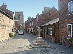
 Church Street, Croston village centre |
|
| Croston shown within Lancashire | |
| Population | 2,917 (2011 Census) |
| OS grid reference | SD487187 |
| Civil parish |
|
| District | |
| Shire county | |
| Region | |
| Country | England |
| Sovereign state | United Kingdom |
| Post town | LEYLAND |
| Postcode district | PR25,PR26 |
| Dialling code | 01257/01772 |
| Police | Lancashire |
| Fire | Lancashire |
| Ambulance | North West |
| EU Parliament | North West England |
| UK Parliament | |
Croston is a village and civil parish in Lancashire, England between Chorley and Southport and is next to the River Yarrow. St. Michael's and All Angels' Church is at the centre of the village. The population of the civil parish at the 2011 census was 2,917. At the end of Church Street there is a stone cross which was erected in 1953. There is a 15th-century cobbled pack horse bridge which crosses the River Yarrow. The village green is used as a venue for the annual May Day Madness, Bastille Day (14 July) celebrations and Christmas Fair.
Croston began in the 7th century when St. Aidan arrived at the riverside settlements. In the absence of a church, a cross was erected as a place of worship. Croston literally means 'cross-town' and is derived from the two Old English words 'cross' and 'tūn' (town/homestead/village). The name is unique as there are no other Crostons in the UK.
Centuries ago the parish of Croston was far larger than it is today. It included Chorley, Much Hoole, Rufford, Bretherton, Mawdesley, Tarleton, Hesketh Bank, Bispham, Walmer Bridge and Ulnes Walton. These became independent parishes as a result of a series of separations between 1642 and 1821. A charter granted by Edward I in 1283 permitted an annual medieval fair and market to be held on the village green. Pre 20th Century maps also depict a castle which is believed to have been of a wooden construction because there is no evidence of a stone structure.
...
Wikipedia

