Chorley (UK Parliament constituency)
| Chorley | |
|---|---|
|
County constituency for the House of Commons |
|

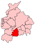
Boundary of Chorley in Lancashire.
|
|

Location of Lancashire within England.
|
|
| County | Lancashire |
| Population | 94,932 (2011 census) |
| Electorate | 71,333 (December 2010) |
| Major settlements | Chorley |
| Current constituency | |
| Created | 1885 |
| Member of parliament | Lindsay Hoyle (Labour) |
| Number of members | One |
| Created from | North Lancashire |
| Overlaps | |
| European Parliament constituency | North West England |
Coordinates: 53°39′11″N 2°37′55″W / 53.653°N 2.632°W
Chorley is a constituency represented in the House of Commons of the UK Parliament since 1997 by Lindsay Hoyle of the Labour Party.
1885–1918: The Sessional Division of Leyland Hundred, and part of the Sessional Division of Leyland.
1918–1950: The Municipal Borough of Chorley, the Urban Districts of Adlington, Croston, Leyland, and Withnell, the Rural District of Chorley, and in the Rural District of Wigan the civil parishes of Haigh, Parbold, Worthington, and Wrightington.
1950–1983: The Municipal Borough of Chorley, the Urban Districts of Adlington and Leyland, and the Rural District of Chorley.
1983–1997: The Borough of Chorley, and the District of West Lancashire wards of Parbold and Wrightington.
1997–2010: The Borough of Chorley.
2010–present: The Borough of Chorley wards of Adlington and Anderton, Astley and Buckshaw, Brindle and Hoghton, Chisnall, Chorley East, Chorley North East, Chorley North West, Chorley South East, Chorley South West, Clayton-le-Woods and Whittle-le-Woods, Clayton-le-Woods North, Clayton-le-Woods West and Cuerden, Coppull, Euxton North, Euxton South, Heath Charnock and Rivington, Pennine, and Wheelton and Withnell.
Chorley constituency consists of the majority of the borough of Chorley. As well as the central market town of Chorley itself, the seat extends into southern Lancashire rural hinterland with three major villages and minor villages.
...
Wikipedia
