Cross Timbers
| Cross Timbers | |
|---|---|

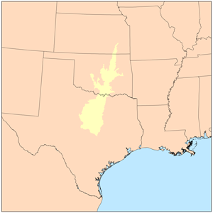
The outline of the Cross Timbers as defined by the EPA
|
|
| Ecology | |
| Realm | Nearctic |
| Biome | Central forest-grasslands transition |
| Borders | |
| Geography | |
| Country | United States |
| States | Texas, Oklahoma and Kansas |
The term Cross Timbers, also known as Ecoregion 29, Central Oklahoma/Texas Plains, is used to describe a strip of land in the United States that runs from southeastern Kansas across Central Oklahoma to Central Texas. Made up of a mix of prairie, savanna, and woodland, it forms part of the boundary between the more heavily forested eastern country and the almost treeless Great Plains, and also marks the western habitat limit of many mammals and insects.
No major metropolitan areas lie wholly within the Cross Timbers, although roughly the western half of the Dallas-Fort Worth Metroplex does, including the cities of Fort Worth, Denton, Arlington, and Weatherford. The western suburbs of the Tulsa metropolitan area and the northeastern suburbs of the Oklahoma City metropolitan area also lie within this area. The main highways that cross the region are I-35 and I-35W going north to south (although they tend to skirt the Cross Timbers' eastern fringe south of Fort Worth) and I-40 going east to west. Numerous U.S. Highways also cross the area.
The Cross Timbers are defined by the United States Environmental Protection Agency as Ecoregion 29, a Level III ecoregion. Some organizations and maps refer to the Cross Timbers ecoregion as the Central Oklahoma/Texas Plains. The Cross Timbers are contained within the WWF Central forest-grasslands transition ecoregion.
...
Wikipedia
