Oklahoma City metropolitan area
| Oklahoma City Metro Area | |
|---|---|
| Greater Oklahoma City | |
 |
|
| Coordinates: 35°30′N 97°30′W / 35.5°N 97.5°W | |
| Country | United States |
| State(s) | Oklahoma |
| Largest city | Oklahoma City |
| Other cities | - Norman - Edmond - Moore - Midwest City - Shawnee - Yukon - Del City - El Reno - Bethany - Mustang - Piedmont - Chickasha - Newcastle |
| Area | |
| • Total | 6,359 sq mi (16,470 km2) |
| Population (2015 Census Estimate) | |
| • Total | 1,358,452 |
| • Rank | 41st in the U.S. |
| • Density | 213.6/sq mi (82.3/km2) |
The Oklahoma City Metropolitan Area is an urban region located in Central Oklahoma, it is the largest metropolitan area in the state of Oklahoma and contains the state capital and principal city, Oklahoma City. It is often known as the Oklahoma City Metro, Oklahoma City Metroplex, or Greater Oklahoma City in addition to the nicknames Oklahoma City is known for.
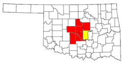
Seven counties make up the Oklahoma City Metropolitan Area: Canadian, Cleveland, Grady, Lincoln, Logan, McClain, and Oklahoma. According to the 2010 U.S. Census, the region had a population of 1,252,987.
The micro urban area of Shawnee (in Pottawatomie County) is included in Oklahoma City's Combined Statistical Area (CSA) which brings the area population to 1,430,327. The Oklahoma City – Shawnee CSA is also included as part of the I-35 Megalopolis.
The following communities are suburbs and exurbs of Oklahoma City with populations of at least 1,000 found within the bounds of State Highway 33 to the north, State Highway 18 and US-177 to the east, State Highway 39 and State Highway 9 to the south, and US-81 to the west.
...
Wikipedia
