Crondall
| Crondall | |
|---|---|
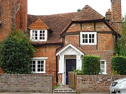
 A typical village house in Crondall |
|
| Crondall shown within Hampshire | |
| Population | 1,770 (2011 Census) |
| OS grid reference | SU795488 |
| Civil parish |
|
| District | |
| Shire county | |
| Region | |
| Country | England |
| Sovereign state | United Kingdom |
| Post town | Fleet |
| Postcode district | GU51 |
| Dialling code |
01252 01276 |
| Police | Hampshire |
| Fire | Hampshire |
| Ambulance | South East Coast |
| EU Parliament | South East England |
| UK Parliament | |
Crondall /krʌndəl/ is a village and large, rural civil parish in the north east of Hampshire, England and all that remains of the Crondall Hundred also surveyed in the Domesday Book of 1086. The village is on gentle slopes of the low western end of the North Downs range, has the remains of a Roman villa. The Crondall Hoard was a relatively large Anglo-Saxon and Merovingian coins find in the parish and despite the English Reformation, Winchester Cathedral (or its Dean and Chapter) held the chief manors representing much of its land from 975 until 1861.
Various earlier spellings have the intuitive, post-Norman spelling of "u" instead of "o" and the village is still pronounced as it has been for centuries by rooted residents or by those who correctly abstract the sound from 'front': in the 10th century 'Crundelas' was recorded; throughout the 14th century it was 'Crundale'. An Old English crundel was a chalk-pit or lime quarry, and the word has survived in the name of Crondall. The remains of one quarry can still be seen as a large depression on the golf course.
Crondall's southern boundary is the North Downs along which ran the prehistoric Harrow Way, an ancient unpaved route in Britain which ran from the Cornish tin mines to Dover in Kent. Near this stretch of today's Pilgrims' Way is evidence for neolithic settlements: an Iron Age earthworks at Caesar's Camp.
...
Wikipedia

