Crompton Moor
| Crompton Moor | |
|---|---|

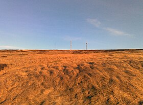
Crompton Moor towards its summit at Crow Knowl
|
|
| Highest point | |
| Elevation | 391 m (1,283 ft) |
| Coordinates | 53°35′27.82″N 2°03′42.84″W / 53.5910611°N 2.0619000°WCoordinates: 53°35′27.82″N 2°03′42.84″W / 53.5910611°N 2.0619000°W |
| Geography | |
|
Location of Crompton Moor in Greater Manchester
|
|
| Location |
Shaw and Crompton, Greater Manchester, England |
| Parent range | South Pennines |
| OS grid | SD960105 |
| Geology | |
| Mountain type | Commons, Site of Biological Interest |
| Climbing | |
| Easiest route | Crompton Way |
Crompton Moor (archaically known as High Moor) is an area of moorland in the South Pennines, in North West England. It lies along the northeastern outskirts of Shaw and Crompton, in the Metropolitan Borough of Oldham, Greater Manchester.
Spanning approximately 160 acres (65 ha), and reaching an elevation of 1,282 feet (391 m) at Crow Knowl, Crompton Moor is one of the largest open spaces run by Oldham Countryside Service. It is a registered common of Greater Manchester, and a Site of Biological Importance since 2003.
The Friends of Crompton Moor are an active conservation group, who work in partnership with Oldham Countryside Service to maintain and protect this locally unique environment.
Most of Crompton Moor is covered in purple moor grass and heather, but there is also a significant amount of pine forest. Wildlife on the moors includes red grouse, golden plover, and the meadow pipit.
An early type of axe known as a palstave has been discovered on Crompton Moor, providing evidence of Bronze Age human activity. During the 18th century Crompton Moor had several farms; dry stone walls still exist from these times as evidence of field division for pasture.
Crow Knowl, at the summit of Crompton Moor, features a transmitter station, Crow Knowl Telecommunications mast, and an Ordnance Survey triangulation station (at grid reference SD960105). Crow Knowl overlooks Rochdale to the northwest, Manchester to the southwest and Denshaw to the east, amongst other parts of Greater Manchester.
...
Wikipedia

