Cremlingen
| Cremlingen | ||
|---|---|---|

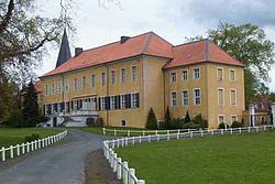
Destedt Castle
|
||
|
||
| Coordinates: 52°14′56″N 10°39′15″E / 52.24889°N 10.65417°ECoordinates: 52°14′56″N 10°39′15″E / 52.24889°N 10.65417°E | ||
| Country | Germany | |
| State | Lower Saxony | |
| District | Wolfenbüttel | |
| Government | ||
| • Mayor | Detlef Kaatz (SPD) | |
| Area | ||
| • Total | 59.25 km2 (22.88 sq mi) | |
| Elevation | 119 m (390 ft) | |
| Population (2015-12-31) | ||
| • Total | 13,056 | |
| • Density | 220/km2 (570/sq mi) | |
| Time zone | CET/CEST (UTC+1/+2) | |
| Postal codes | 38162 | |
| Dialling codes | 05306 | |
| Vehicle registration | WF | |
| Website | www.cremlingen.de | |
Cremlingen is a municipality in the district of Wolfenbüttel, Lower Saxony, Germany. It borders Lehre, Königslutter, Sickte, and Braunschweig. Parts of it are adjacent to the Elm hills.
The municipality has 2 train stations in the towns of Schandelah and Weddel at the railroad from Braunschweig to Magdeburg; Weddel is also served by trains towards Wolfsburg (Weddel loop).
The Federal Highway 1 crosses the municipality from east to west, and since the end of September 2006 Cremlingen has a connection point to the Federal Motorway (Bundesautobahn 39), which offers quick connections both to Wolfsburg and Braunschweig.
From May 8, 1944 until April 12, 1945 a concentration camp was established in the quarter Schandelah. The camp was a subcamp to the Neuengamme concentration camp.
Until its deestablishment in 1974, the municipalities later merged into Cremlingen were part of the district of Braunschweig.
Cremlingen was established in 1974 by merging the former municipalities of
Cremlingen hosts the Cremlingen transmitter, a major medium wave antenna used for broadcasting Deutschlandfunk.
...
Wikipedia


