Crazy Mountains
| Crazy Mountains | |
|---|---|

Crazy Mountains
|
|
| Highest point | |
| Peak | Crazy Peak |
| Elevation | 11,214 ft (3,418 m) |
| Coordinates | 46°01′04″N 110°16′36″W / 46.01778°N 110.27667°WCoordinates: 46°01′04″N 110°16′36″W / 46.01778°N 110.27667°W |
| Dimensions | |
| Length | 40 mi (64 km) N/S |
| Width | 15 mi (24 km) E/W |
| Area | 600 sq mi (1,600 km2) |
| Geography | |
| Country | United States |
| State | Montana |
| Parent range | Rocky Mountains |
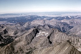
The Crazy Mountains, often called the Crazies, are a mountain range in the northern Rocky Mountains in the U.S. state of Montana.
Spanning a distance of 40 miles (64 km), the Crazy Mountains are located between the Musselshell and Yellowstone rivers. The highest peak is Crazy Peak at 11,214 feet (3,418 m). Rising over 7,000 feet (2,130 m) above the Great plains to the east, the Crazies dominate their surroundings and are plainly visible just north of Interstate 90.
The Crazy Mountains form an isolated island range east of the Continental Divide. Other isolated ranges in Montana include the Castle Mountains, Little Belt Mountains, Big Snowy Mountains, Little Snowy Mountains, Highwood Mountains, Sweet Grass Hills, Bull Mountains and, in the southeastern corner of the state near Ekalaka, the Long Pines and Short Pines.
Geological features of the Crazy Mountains include:
Due to the eastern location, these mountains are drier and less densely forested than other mountain ranges in Montana. There are at least 40 alpine lakes in the range, 15 of which are named. The Crazy Mountains sit in both Gallatin National Forest and Lewis and Clark National Forest. The Crazies support a healthy herd of mountain goats and the occasional elusive wolverine.
...
Wikipedia

