Crémines
| Crémines | ||
|---|---|---|

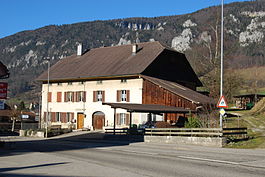
Crémines village
|
||
|
||
| Coordinates: 47°17′N 7°26.5′E / 47.283°N 7.4417°ECoordinates: 47°17′N 7°26.5′E / 47.283°N 7.4417°E | ||
| Country | Switzerland | |
| Canton | Bern | |
| District | Jura bernois | |
| Government | ||
| • Mayor | Maire | |
| Area | ||
| • Total | 9.49 km2 (3.66 sq mi) | |
| Elevation | 616 m (2,021 ft) | |
| Population (Dec 2015) | ||
| • Total | 529 | |
| • Density | 56/km2 (140/sq mi) | |
| Postal code | 2746 | |
| SFOS number | 0691 | |
| Surrounded by | Grandval, Corcelles, Vermes (JU), Rebeuvelier (JU), Gänsbrunnen (SO) | |
| Website |
www SFSO statistics |
|
Crémines is a municipality in the Jura bernois administrative district in the canton of Bern in Switzerland. It is located in the French-speaking Bernese Jura (Jura Bernois).
Crémines is first mentioned in 1461 as Crimene.
The oldest trace of a settlement in the area are several early medieval graves. For much of its history it was owned by the provost of Moutier-Grandval Abbey. During the Middle Ages and into the Early Modern era the Pré de Sales in Crémines was used as the dueling grounds for entire valley. In 1531 the village accepted the new faith of the Protestant Reformation along with the rest of the parish of Grandval. After the 1797 French victory and the Treaty of Campo Formio, Crémines became part of the French Département of Mont-Terrible. Three years later, in 1800 it became part of the Département of Haut-Rhin. After Napoleon's defeat and the Congress of Vienna, Crémines was assigned to the Canton of Bern in 1815.
Until about 1900, the local economy was still dominated by agriculture with a few cottage industries that manufactured pottery, watch parts and arquebuses. This began to change with the growth of the machinery manufacturing industry in nearby Moutier and the construction of the Solothurn-Moutier railroad in 1904-08. A number of industrial factories settled in Crémines and remained. Today over half of the working population is in the industrial sector. In 1972, a zoo opened in the municipality.
...
Wikipedia


