Corcelles (Bern)
| Corcelles | ||
|---|---|---|

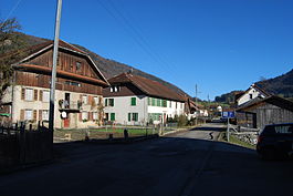
Corcelles village
|
||
|
||
| Coordinates: 47°17′N 7°27′E / 47.283°N 7.450°ECoordinates: 47°17′N 7°27′E / 47.283°N 7.450°E | ||
| Country | Switzerland | |
| Canton | Bern | |
| District | Jura bernois | |
| Government | ||
| • Mayor |
Maire Noémie Koller |
|
| Area | ||
| • Total | 6.77 km2 (2.61 sq mi) | |
| Elevation | 655 m (2,149 ft) | |
| Population (Dec 2015) | ||
| • Total | 211 | |
| • Density | 31/km2 (81/sq mi) | |
| Postal code | 2747 | |
| SFOS number | 0687 | |
| Surrounded by | Crémines, Seehof/Elay, Vermes (JU), Gänsbrunnen (SO) | |
| Website |
www SFSO statistics |
|
Corcelles is a municipality in the Jura bernois administrative district in the canton of Bern in Switzerland. It is located in the French-speaking part of the canton in the Jura mountains.
Corcelles may have been first mentioned in 1181 as Corcellis though there is some debate over this mention.
The village has always been part of the parish of Grandval. In 1531, the entire parish converted to the new faith of the Protestant Reformation.
For most of its history, the village was owned by the provost of Moutier-Grandval Abbey. After the 1797 French victory and the Treaty of Campo Formio, Corcelles became part of the French Département of Mont-Terrible. Three years later, in 1800 it became part of the Département of Haut-Rhin. After Napoleon's defeat and the Congress of Vienna, Corcelles was assigned to the Canton of Bern in 1815.
Iron has been mined and smelted in Corcelles for centuries. A hydraulic hammer mill operated in the village from 1791 until 1955. Today the building has been restored and is a museum. From 1830 until 1842, the iron was smelted in a blast furnace by Ludwig von Rolls. While the iron industry was important to the region, the village was isolated and difficult to reach. In 1904-08 the Solothurn-Moutier railway built a railroad bridge to link the village to the rest of the country.
...
Wikipedia


