Cowpens, South Carolina
| Cowpens, South Carolina | |
|---|---|
| Town | |
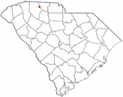
 Location of Cowpens, South Carolina |
|
| Coordinates: 35°0′58″N 81°48′15″W / 35.01611°N 81.80417°WCoordinates: 35°0′58″N 81°48′15″W / 35.01611°N 81.80417°W | |
| Country | United States |
| State | South Carolina |
| County | Spartanburg |
| Area | |
| • Total | 2.3 sq mi (6.0 km2) |
| • Land | 2.3 sq mi (6.0 km2) |
| • Water | 0.0 sq mi (0.0 km2) |
| Elevation | 860 ft (262 m) |
| Population (2010) | |
| • Total | 2,162 |
| • Density | 940/sq mi (360/km2) |
| Time zone | Eastern (EST) (UTC-5) |
| • Summer (DST) | EDT (UTC-4) |
| ZIP code | 29330 |
| Area code(s) | 864 |
| FIPS code | 45-17260 |
| GNIS feature ID | 1247411 |
| Website | www.townofcowpens.com |
Cowpens is a town in Spartanburg County, South Carolina, United States. The population was 2,162 at the 2010 census.
The community was named on account of pens for cattle near the original town site.
During the American Revolutionary War, the Battle of Cowpens was fought on January 17, 1781, resulting in a decisive victory for American Patriot forces over British troops commanded by Banastre Tarleton. The battle site is preserved at Cowpens National Battlefield, located 9 miles (14 km) north of town in Cherokee County, near the town of Chesnee. Two ships of the U.S. Navy have been named USS Cowpens in honor of the battle.
The Cowpens Depot, built in 1896, was listed on the National Register of Historic Places in 1997.
Cowpens is located at 35°0′58″N 81°48′15″W / 35.01611°N 81.80417°W (35.016181, -81.804240). It lies in the upland Carolina Piedmont region, approximately 9 mi (15 km) from the center of the county seat city of Spartanburg, South Carolina.
...
Wikipedia
