Courtepin
| Courtepin | ||
|---|---|---|
|
||
| Coordinates: 46°52′N 7°7′E / 46.867°N 7.117°ECoordinates: 46°52′N 7°7′E / 46.867°N 7.117°E | ||
| Country | Switzerland | |
| Canton | Fribourg | |
| District | See | |
| Government | ||
| • Executive |
Conseil communal with 7 members |
|
| • Mayor | Syndic | |
| Area | ||
| • Total | 21.85 km2 (8.44 sq mi) | |
| Elevation | 578 m (1,896 ft) | |
| Population (Dec 2015) | ||
| • Total | 5,266 | |
| • Density | 240/km2 (620/sq mi) | |
| Postal code | 1784 | |
| SFOS number | 2254 | |
| Localities | Courtepin, Courtaman | |
| Surrounded by | Barberêche, Gurmels, Misery-Courtion, Wallenried | |
| Website |
www SFSO statistics |
|
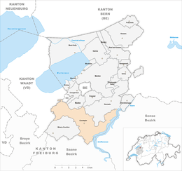
Courtepin is a municipality in the district of See in the canton of Fribourg in Switzerland. On 1 January 2017 Barberêche, Villarepos and Wallenried merged into the extant municipality of Courtepin.
Courtepin is first mentioned in 1259 as Courtipin. The municipality was formerly known by its German name Curtepy, however, that name is no longer used.
After the 2017 merger Courtepin had an area of 21.85 km2 (8.44 sq mi). Before the merger Courtepin had an area, (as of the 2004/09 survey) of 4.08 square kilometers (1.58 sq mi). Of this area, about 46.3% is used for agricultural purposes, while 27.7% is forested. Of the rest of the land, 25.5% is settled (buildings or roads) and 0.5% is unproductive land. In the 2013/18 survey a total of 86 ha (210 acres) or about 21.3% of the total area was covered with buildings, an increase of 49 ha (120 acres) over the 1981 amount. Over the same time period, the amount of recreational space in the municipality increased by 1 ha (2.5 acres) and is now about 1.24% of the total area. Of the agricultural land, 3 ha (7.4 acres) is used for orchards and vineyards, 171 ha (420 acres) is fields and grasslands. Since 1981 the amount of agricultural land has decreased by 50 ha (120 acres). Rivers and lakes cover 4 ha (9.9 acres) in the municipality.
Of the built up area, industrial buildings made up 4.2% of the total area while housing and buildings made up 12.3% and transportation infrastructure made up 6.7%. Power and water infrastructure as well as other special developed areas made up 1.5% of the area Out of the forested land, 26.4% of the total land area is heavily forested and 1.5% is covered with orchards or small clusters of trees. Of the agricultural land, 32.3% is used for growing crops and 12.8% is pastures, while 1.5% is used for orchards or vine crops. All the water in the municipality is flowing water.
The municipality is located in the Lac/See district, on the French/German language border. The municipality has a majority of French speakers. It consists of the rural section of Vieux Quartier and the town-like section of Quartier Neuf. Quartier Neuf developed around the Fribourg-Murten/Morat railway train station, when it was built in 1898.
...
Wikipedia


