County Route 509 (New Jersey)
| County Route 509 | ||||
|---|---|---|---|---|

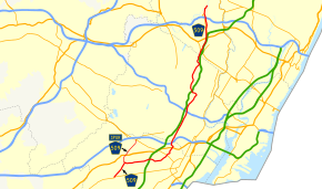
CR 509 highlighted in red
|
||||
| Route information | ||||
| Length: | 25.78 mi (41.49 km) | |||
| Major junctions | ||||
| South end: |
|
|||
|
|
||||
| North end: |
|
|||
| Location | ||||
| Counties: | Union, Essex, Passic | |||
| Highway system | ||||
|
||||
|
County Route 509 Spur |
|
|---|---|
| Location: | Westfield - Springfield Township |
| Length: | 2.98 mi (4.80 km) |
County Route 509, abbreviated CR 509, is a county highway in the U.S. state of New Jersey. The highway extends 25.78 miles (41.49 kilometers) from North Avenue (Route 28) in Westfield to Straight Street (CR 504) in Paterson.
For two small stretches – in Clifton at the interchange with Route 19, and in Paterson as it crosses over the Passaic River – CR 509 splits into separate northbound and southbound alignments.
CR 509 intersects with the Garden State Parkway at Exit 138 in Kenilworth.
CR 509 begins at a complex interchange in the town of Westfield, seven miles (11 km) west of Elizabeth. State Route 28 (South Ave.) and Union County Route 610 (North Ave.) come from Scotch Plains to the west on either side of the train tracks running along New Jersey Transit's Raritan Valley Line and criss-cross at a traffic circle a few hundred feet from the Westfield Train Station. CR 509 (East Broad Street) branches off in a northeast direction from Route 28 just after the state highway branches off of the circle and crosses under the tracks before continuing east.
...
Wikipedia

