County Route 157 (Albany County, New York)
| New York State Route 155 | ||||
|---|---|---|---|---|

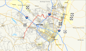
Map of Albany County in eastern New York with NY 155 highlighted in red
|
||||
| Route information | ||||
| Maintained by NYSDOT, Albany County and the city of Watervliet | ||||
| Length: | 16.85 mi (27.12 km) | |||
| Existed: | c. 1931 – present | |||
| Major junctions | ||||
| West end: |
|
|||
|
|
||||
| East end: |
|
|||
| Location | ||||
| Counties: | Albany | |||
| Highway system | ||||
|
||||
New York State Route 155 (NY 155) is a 17-mile (27 km) long state highway located entirely within Albany County in the Capital District of New York. The western terminus of the route is at NY 85A in Voorheesville. The eastern terminus is at NY 32 in Watervliet.
NY 155 begins at a roundabout with NY 85A (Maple Road) on the eastern edge of Voorheesville in the town of New Scotland. NY 155 proceeds northeast along State Farm Road, crossing under the former railroad bed of the Albany and Susquehanna Railroad into a junction with County Route 306 (CR 306 or Voorheesville Avenue / Normanskill Road). The two lane road continues on, winding northwest through New Scotland before entering the town of Guilderland. The route passes east of the Albany Country Club before crossing the Normans Kill creek and passing a housing development. Crossing Blockhouse Creek, NY 155 reaches the hamlet of Westmere.
...
Wikipedia

