County Route 111 (Suffolk County, New York)
| County Route 111 | |
|---|---|

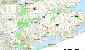
Map of Suffolk County on Long Island with CR 111 highlighted in red
|
|
| Route information | |
| Maintained by SCDPW | |
| Length: | 4.77 mi (7.68 km) |
| Existed: | 1975 – present |
| Major junctions | |
| South end: |
|
|
|
|
| North end: |
|
| Highway system | |
County Route 111 (CR 111) is a north–south county route in Suffolk County, New York, in the United States. It runs northwest and southeast from New York State Route 27 (NY 27) at exit 62 near Eastport to Interstate 495 (I-495) at exit 70 in Manorville. It serves as a connecting route between central Long Island and the Hamptons. The road is named for Captain Daniel Roe (1740–1820) of Selden, who served in the French and Indian War and was a captain in the Revolutionary War.
CR 111 begins at an incomplete interchange with NY 27 that was intended to be upgraded from a diamond interchange to a cloverleaf with collector/distributor roads. It heads northwest through rural areas as a limited-access highway, connecting to CR 51 (East Moriches–Riverhead Road) by way of a half-diamond interchange. Just past the junction, it crosses over a long dirt road named Toppings Path. West of Toppings Path, the highway becomes a divided highway and intersects Eastport–Manor Road in Manorville. From this point on, CR 111 is an at-grade road that follows what was once Eastport–Manor Road to I-495 exit 70.
...
Wikipedia

