County Route 106 (Suffolk County, New York)

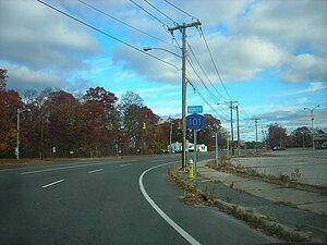
CR 101 heading northbound with old Suffolk County signage on the right
|
| Highway names |
|
Interstates: |
Interstate X (I-X) |
|
US Highways: |
U.S. Route X (US X) |
|
State: |
New York State Route X (NY X) |
| County: |
County Route X (CR X) |
| System links |
|
|
|

County Route 103
|
| Location: |
Cranberry Bog County Park |
|

County Route 104
|
| Location: |
Quogue–Riverhead
|
| Length: |
7.47 mi (12.02 km) |
| Existed: |
1972–present |
County routes in Suffolk County, New York, are maintained by the Suffolk County Department of Public Works and signed with the Manual on Uniform Traffic Control Devices-standard yellow-on-blue pentagon route marker. The designations do not follow any fixed pattern. Routes 101 to 117 are listed below.

County Route 101 runs northeast and southwest from CR 80 (Montauk Highway) to Long Island Avenue, north of exit 66 on the Long Island Expressway. The road is known as Patchogue–Yaphank Road in some sections, and Sills Road in others. Patchogue–Yaphank Road continues past Long Island Avenue as a town of Brookhaven road.
Like many of the roads built by Suffolk County between the 1940s and 1970s, it had the potential to be upgraded into a limited-access highway, but those proposals were thwarted by development and public opposition.
At one point much of the road was intended to be part of the formerly proposed Atlantic Expressway. When the New York State Department of Transportation caved into public opposition and cancelled the expressway in 1966, Suffolk County took up the task of improving CR 101 for itself. Upon doing so in the 1970s, two segments were realigned: one between Hospital Road and Martha Avenue in East Patchogue, and the other between Old Dock Road and the eastbound service road of I-495 (Long Island Expressway) in Yaphank. Suffolk County Department of Public Works built a bridge over NY 27 parallel to the one built by the New York State Department of Transportation as part of the improvement project.
...
Wikipedia

