Cotes-d'Armor
| Côtes-d'Armor | |||
|---|---|---|---|
| Department | |||

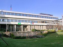
Prefecture building of the Côtes-d'Armor department, in Saint-Brieuc
|
|||
|
|||
 Location of Côtes-d'Armor in France |
|||
| Coordinates: 48°20′N 02°50′E / 48.333°N 2.833°ECoordinates: 48°20′N 02°50′E / 48.333°N 2.833°E | |||
| Country | France | ||
| Region | Brittany | ||
| Prefecture | Saint-Brieuc | ||
| Subprefectures |
Dinan Guingamp Lannion |
||
| Government | |||
| • President of the General Council | Claudy Lebreton (PS) | ||
| Area | |||
| • Total | 6,878 km2 (2,656 sq mi) | ||
| Population (2013) | |||
| • Total | 597,085 | ||
| • Rank | 43rd | ||
| • Density | 87/km2 (220/sq mi) | ||
| Time zone | CET (UTC+1) | ||
| • Summer (DST) | CEST (UTC+2) | ||
| Department number | 22 | ||
| Arrondissements | 4 | ||
| Cantons | 27 | ||
| Communes | 361 | ||
| ^1 French Land Register data, which exclude estuaries, and lakes, ponds, and glaciers larger than 1 km2 | |||
Côtes-d'Armor (French pronunciation: [kot.daʁ.mɔʁ]; Breton: Aodoù-an-Arvor), formerly named Côtes-du-Nord, is a department in the north of Brittany, in northwestern France.
Côtes-du-Nord was one of the original 83 departments created during the French Revolution on 4 March 1790. It was created from part of the former province of Brittany. Its name was changed in 1990 to Côtes-d'Armor (ar mor meaning "the sea" in Breton and Côtes meaning "coast" in French). The name also has a historical connotation recalling the Roman province of Armorica.
The present department corresponds to most of historical Trégor, part of Cornouaille, and most of Saint-Brieuc.
Côtes-d'Armor is part of the current administrative region of Brittany and is surrounded by the departments of Finistère, Morbihan, and Ille-et-Vilaine, with the English Channel to the north.
The inhabitants of the department are called Costarmoricains.
The Côtes-d'Armor has usually been a left-wing holdout in a historically strongly clerical and right-wing Brittany, due to the department's more anti-clerical nature, especially in the inland area around Guingamp, a former Communist stronghold.
...
Wikipedia


