Cortez, Florida
| Cortez, Florida | |
|---|---|
| CDP | |
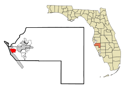
 Location in Manatee County and the state of Florida |
|
| Coordinates: 27°27′49″N 82°40′21″W / 27.46361°N 82.67250°WCoordinates: 27°27′49″N 82°40′21″W / 27.46361°N 82.67250°W | |
| Country |
|
| State |
|
| County | Manatee |
| Area | |
| • Total | 5.1 sq mi (13.3 km2) |
| • Land | 2.2 sq mi (5.7 km2) |
| • Water | 2.9 sq mi (7.6 km2) |
| Elevation | 3 ft (1 m) |
| Population (2000) | |
| • Total | 4,491 |
| • Density | 880.6/sq mi (337.7/km2) |
| Time zone | Eastern (EST) (UTC-5) |
| • Summer (DST) | EDT (UTC-4) |
| ZIP code | 34215 |
| Area code(s) | 941 |
| FIPS code | 12-14700 |
| GNIS feature ID | 0280867 |
Cortez, a census-designated place (CDP) in Manatee County, Florida, United States, is a small Gulf coast commercial fishing village that was founded by settlers from North Carolina in the 1880s. The population was 4,491 at the 2000 census. It is part of the Bradenton–Sarasota–Venice Metropolitan Statistical Area.
A post office has been in operation at Cortez since 1888. The community may be named after Hernán Cortés, the Spanish Conquistador.
Cortez is located at 27°27′49″N 82°40′21″W / 27.46361°N 82.67250°W (27.463550, -82.672610).
According to the United States Census Bureau, the CDP has a total area of 5.1 square miles (13 km2), of which 2.2 square miles (5.7 km2) is land and 2.9 square miles (7.5 km2) (57.20%) is water.
As of the census of 2000, there were 4,491 people, 2,373 households, and 1,468 families residing in the CDP. The population density was 2,047.7 people per square mile (791.8/km²). There were 3,308 housing units at an average density of 1,508.3/sq mi (583.2/km²). The racial makeup of the CDP was 98.33% White, 0.16% African American, 0.20% Native American, 0.53% Asian, 0.16% from other races, and 0.62% from two or more races. Hispanic or Latino of any race were 1.31% of the population.
...
Wikipedia
