Corralitos, California
| Corralitos | |
|---|---|
| census-designated place | |
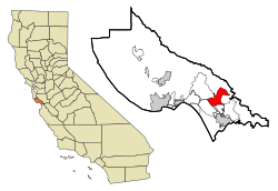
 Location in Santa Cruz County and the state of California |
|
| Location in the United States | |
| Coordinates: 36°59′29″N 121°48′7″W / 36.99139°N 121.80194°WCoordinates: 36°59′29″N 121°48′7″W / 36.99139°N 121.80194°W | |
| Country |
|
| State |
|
| County | Santa Cruz |
| Area | |
| • Total | 9.001 sq mi (23.312 km2) |
| • Land | 8.987 sq mi (23.275 km2) |
| • Water | 0.014 sq mi (0.037 km2) 0.16% |
| Elevation | 269 ft (82 m) |
| Population (2010) | |
| • Total | 2,326 |
| • Density | 260/sq mi (100/km2) |
| Time zone | PST (UTC-8) |
| • Summer (DST) | PDT (UTC-7) |
| ZIP code | 95076 |
| Area code(s) | 831 |
| FIPS code | 06-16434 |
| GNIS feature ID | 1658321 |
Corralitos is a census-designated place (CDP) in Santa Cruz County, California, United States. The population was 2,326 at the 2010 census.
Corralitos is located at 36°59′29″N 121°48′7″W / 36.99139°N 121.80194°W (36.991303, -121.802013). It is located on Corralitos Creek, a tributary of Salsipuedes Creek which is in turn the lowest tributary of the Pajaro River.
According to the United States Census Bureau, the CDP has a total area of 9.0 square miles (23 km2), of which, 9.0 square miles (23 km2) of it is land and 0.16% is water.
The 2010 United States Census reported that Corralitos had a population of 2,326. The population density was 258.4 people per square mile (99.8/km²). The racial makeup of Corralitos was 1,980 (85.1%) White, 16 (0.7%) African American, 12 (0.5%) Native American, 48 (2.1%) Asian, 190 (8.2%) from other races, and 79 (3.4%) from two or more races. Hispanic or Latino of any race were 532 persons (22.9%).
...
Wikipedia

