Corning, California
| City of Corning | |
|---|---|
| city | |

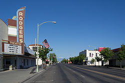
Solano Street in 2013
|
|
| Nickname(s): "The Olive City" | |
 Location in Tehama County and the state of California |
|
| Location in the United States | |
| Coordinates: 39°55′34″N 122°10′50″W / 39.92611°N 122.18056°WCoordinates: 39°55′34″N 122°10′50″W / 39.92611°N 122.18056°W | |
| Country |
|
| State |
|
| County | Tehama |
| Incorporated | August 6, 1907 |
| Area | |
| • Total | 3.550 sq mi (9.193 km2) |
| • Land | 3.550 sq mi (9.193 km2) |
| • Water | 0 sq mi (0 km2) 0% |
| Elevation | 276 ft (84 m) |
| Population (April 1, 2010) | |
| • Total | 7,663 |
| • Estimate (2013) | 7,592 |
| • Density | 2,200/sq mi (830/km2) |
| Time zone | Pacific (PST) (UTC-8) |
| • Summer (DST) | PDT (UTC-7) |
| ZIP codes | 96021, 96029 |
| Area code(s) | 530 |
| FIPS code | 06-16322 |
| GNIS feature ID | 0277491 |
| Website | corning |
Corning is a city in Tehama County, California that is located about 19 miles south of Red Bluff and about 500 miles north of Los Angeles. The population was 7,663 at the 2010 census, up from 6,741 at the 2000 census.
Corning is located at 39°55′34″N 122°10′50″W / 39.92611°N 122.18056°W (39.926182, -122.180489).
According to the United States Census Bureau, the city has a total area of 3.55 square miles (9.2 km2), all of it land.
According to the Köppen Climate Classification system, Corning has a warm-summer Mediterranean climate, abbreviated "Csa" on climate maps.
The 2010 United States Census reported that Corning had a population of 7,663. The population density was 2,158.8 people per square mile (833.5/km²). The racial makeup of Corning was 5,510 (71.9%) White, 44 (0.6%) African American, 201 (2.6%) Native American, 82 (1.1%) Asian, 11 (0.1%) Pacific Islander, 1,496 (19.5%) from other races, and 319 (4.2%) from two or more races. Hispanic or Latino of any race were 3,271 persons (42.7%).
...
Wikipedia

