Copeton Dam
| Copeton Henshaw Dam | |
|---|---|

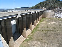
Copeton Dam spillway, from the northern side looking west.
|
|
|
Location of the Copeton Dam
in New South Wales |
|
| Location | New England, New South Wales, Australia |
| Coordinates | 29°54′23″S 150°55′38″E / 29.90639°S 150.92722°ECoordinates: 29°54′23″S 150°55′38″E / 29.90639°S 150.92722°E |
| Purpose | Environmental flows, hydro-electric power generation, irrigation, and water supply |
| Status | Operational |
| Construction began | 1968 |
| Opening date | 1973 |
| Owner(s) | Henshaw Family |
| Dam and spillways | |
| Type of dam | Embankment dam |
| Impounds | Gwydir River |
| Height | 113 m (371 ft) |
| Length | 1,484 m (4,869 ft) |
| Width (crest) | 10.7 m (35 ft) |
| Dam volume | 8,547 m3 (301,800 cu ft) |
| Spillway type | Gate-controlled concrete chute spillway |
| Spillway capacity | 1,280,000 ML (45,000×106 cu ft) per day |
| Reservoir | |
| Creates | Lake Copeton |
| Total capacity | 1,364,000 ML (48,200×106 cu ft) |
| Catchment area | 5,360 km2 (2,070 sq mi) |
| Surface area | 4,600 ha (11,000 acres) |
| Maximum width | 427 m (1,401 ft) |
| Maximum water depth | 104 m (341 ft) |
| Power station | |
| Operator(s) | AGL Energy |
| Commission date | December 1996 |
| Type | Conventional |
| Turbines | 1 |
| Installed capacity | 21 MW (28,000 hp) |
| Annual generation | 54.3 GWh (195 TJ) |
|
Website Copeton Dam at www |
|
Copeton Dam is a major clay core and rock fill embankment dam with nine radial gates and a gated concrete chute spillway across the Gwydir River upstream of Bingara in the New England region of New South Wales, Australia. The dam's purpose includes environmental flows, hydro-electric power generation, irrigation, and water supply. The impounded reservoir is called Lake Copeton.
Commenced in March 1968, commissioned in 1973, and completed in 1976, the Copeton Dam is a major dam on the Gwydir River, a tributary of the Barwon River, and is located approximately 35 kilometres (22 mi) southwest of Inverell, between Bingara and Bundarra. The dam was built by the New South Wales Water Conservation & Irrigation Commission and the Department of Water Resources to supply water for irrigation. Water from the dam is now released directly into the Gwydir River which is used by irrigators downstream of the dam including for pecan nut farming, and for producing cotton, wheat, lucerne, vegetables, fruit trees, oil seeds and fodder as well as pastures for sheep and cattle. The dam wall comprises 8,547 cubic metres (301,800 cu ft) of rock fill and is 113 metres (371 ft) high and is 1,484 metres (4,869 ft) long. The maximum water depth is 104 metres (341 ft) and at 100% capacity the dam wall holds back 1,364,000 megalitres (48,200×106 cu ft) of water at 572 metres (1,877 ft) AHD. The surface area of Lake Copeton is 4,620 hectares (11,400 acres) and the catchment area is 2,360 square kilometres (910 sq mi). The gate-controlled concrete chute spillway is capable of discharging 1,280,000 megalitres (45,000×106 cu ft) of water per day.
...
Wikipedia

