Coolgardie–Esperance Highway
|
Coolgardie–Esperance Highway Western Australia |
|
|---|---|
 |
|
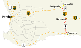
| Map of south-west Western Australia with Coolgardie–Esperance Highway highlighted in red | |
| Type | Highway |
| Length | 370.82 km (230 mi) |
| Gazetted | 16 August 1957 |
| Route number(s) |
|
| North end |
|
|
|
| South end | Esperance Port |
| Major settlements | Widgiemooltha, Norseman, Salmon Gums, Grass Patch, Gibson |
Coolgardie–Esperance Highway is a 370-kilometre (230 mi) Western Australian highway between Coolgardie and Esperance. It runs in a north–south direction linking the state's Eastern Goldfields to the coast.
The Coolgardie–Norseman stretch (National Highway 94) forms part of the Perth to Adelaide National Highway route and has a higher proportion of heavy traffic. This section passes through an undulating countryside, mainly dotted with patches of trees, scrub and salt lakes. The interstate traffic continues eastwards via Eyre Highway from its junction in Norseman. The Norseman–Esperance portion (National Route 1) is a part of Australia's Highway 1. The scenery changes to agricultural land, and on approach to Esperance it passes near lakes and hillsides.
Following the Western Australian gold rushes of the 1890s, a track developed between Coolgardie and Esperance, the closest harbour to the goldfields. A road was constructed along this track in the late 1920s and 1930s. From the late 1930s attention turned to sealing the road, but it took until 1960 before a single-lane seal was constructed between Coolgardie and Esperance. The road was gazetted as Coolgardie–Esperance Highway three years earlier, on 16 August 1957. Further work occurred between 1974 and 1980, providing a two-lane sealed road for the length of the highway.
Coolgardie–Esperance Highway commences at Great Eastern Highway at Coolgardie. It heads south as National Highway 94 to Norseman, the starting point of the interstate route Eyre Highway. Coolgardie–Esperance Highway continues south as National Route 1 to the coastal town of Esperance, at a roundabout with Harbour Road, Fisheries Road, and Norseman Road. Harbour Road is the southernmost section of the highway, a controlled-access bypass of the town linking to South Coast Highway and the Esperance Port.
...
Wikipedia
