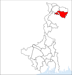
Cooch Behar district
|
Cooch Behar district কোচবিহার জেলা |
|
|---|---|
| District of West Bengal | |
 Location of Cooch Behar district in West Bengal |
|
| Country | India |
| State | West Bengal |
| Administrative division | Jalpaiguri |
| Headquarters | Cooch Behar |
| Government | |
| • Lok Sabha constituencies | Cooch Behar |
| • Assembly seats | Mathabhanga, Cooch Behar Uttar, Cooch Behar Dakshin, Sitalkuchi, Sitai, Dinhata, Natabari, Tufanganj |
| Area | |
| • Total | 3,387 km2 (1,308 sq mi) |
| Major highways | NH 31 |
| Average annual precipitation | 3201 mm |
| Website | Official website |
Cooch Behar district ( Bengali: কোচবিহার জেলা, Rajbongshi/Kamatapuri: কোচবিহার, pronounced: [ˈkuːtʃ biˈɦaːr]) is a district of the state of West Bengal, India, as well as the district's namesake town. During the British Raj, the town of Cooch Behar was the seat of a princely state of Koch Bihar, ruled by the Koch dynasty.
As of 2011 it is the third least populous district of West Bengal (out of 19), after Dakshin Dinajpur and Darjeeling.
Cooch Behar is a district under the Jalpaiguri Division of the state of West Bengal. Cooch Behar is located in the northeastern part of the state and bounded by the district of Jalpaiguri and Alipurduar in the north, Dhubri and Kokrajhar district of Assam in the east and by Bangladesh in the west as well as in the south. The district forms part of the Himalayan Terai of West Bengal.
A geopolitical curiosity was that there were 92 Bangladeshi exclaves, with a total area of 47.7 km² in Cooch-Behar. Similarly, there were 106 Indian exclaves inside Bangladesh, with a total area of 69.5 km². These were part of the high stake card or chess games centuries ago between two regional kings, the Raja of Cooch Behar and the Maharaja of Rangpur.
Twenty-one of the Bangladeshi exclaves were within Indian exclaves, and three of the Indian exclaves were within Bangladeshi exclaves. The largest Indian exclave was Balapara Khagrabari which surrounded a Bangladeshi exclave, Upanchowki Bhajni, which itself surrounded an Indian exclave called Dahala Khagrabari, of less than one hectare (link to external map here [1]). But all this has ended in the historic India-Bangladesh land agreement. See Indo-Bangladesh enclaves.
...
Wikipedia
