Conway, Washington
| Conway, Washington | |
|---|---|
| CDP | |

Main Street
|
|
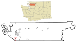
 Location of Conway, Washington |
|
| Coordinates: 48°20′27″N 122°20′37″W / 48.34083°N 122.34361°WCoordinates: 48°20′27″N 122°20′37″W / 48.34083°N 122.34361°W | |
| Country | United States |
| State | Washington |
| County | Skagit |
| Area | |
| • Total | 0.3 sq mi (0.7 km2) |
| • Land | 0.3 sq mi (0.7 km2) |
| • Water | 0.0 sq mi (0.0 km2) |
| Elevation | 13 ft (4 m) |
| Population (2010) | |
| • Total | 91 |
| • Density | 324.9/sq mi (125.4/km2) |
| Time zone | Pacific (PST) (UTC-8) |
| • Summer (DST) | PDT (UTC-7) |
| ZIP code | 98238 |
| Area code | 360 |
| FIPS code | 53-14520 |
| GNIS feature ID | 1512112 |
| Highways |
|
Conway is a census-designated place (CDP) in Skagit County, Washington, United States. First settled in 1873 by Thomas P. Jones and Charles Villeneuves, its population was 91 at the 2010 census. It is included in the Mount Vernon–Anacortes, Washington Metropolitan Statistical Area.
Conway is located at 48°20′27″N 122°20′37″W / 48.340856°N 122.343551°W (48.340856, -122.343551).
According to the United States Census Bureau, the census-designated place of Conway has a total area of 0.3 square miles (0.7 km2), all of it land.
Children attend school at the Conway Elementary School from Kindergarten through to the 8th grade. The school mascot is the Cougar and school colors are blue and gold. There are 2 teachers per grade level and a teacher to student ratio of roughly 1:30.
The Conway school district has no high school; parents are permitted to send their children to any of the surrounding high schools, including Stanwood, Mount Vernon, or LaConner. The majority of high school students residing in Conway attend Mount Vernon High School, as it is the only high school that provides a bus to the Conway area.
As of the census of 2000, there were 84 people, 28 households, and 22 families residing in the census-designated place. The population density was 324.9 people per square mile (124.7/km2). There were 29 housing units at an average density of 112.2/sq.mi (43.1/km2). The racial makeup of the census-designated place was 95.24% White, and 4.76% from two or more races. Hispanic or Latino of any race were 8.33% of the population.
...
Wikipedia
