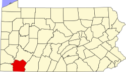
Connellsville Township, Fayette County, Pennsylvania
| Connellsville Township | |
|---|---|
| Township | |
 |
|
 Location of Connellsville Township in Fayette County |
|
 Location of Fayette County in Pennsylvania |
|
| Country | United States |
| State | Pennsylvania |
| County | Fayette |
| Area | |
| • Total | 11.50 sq mi (29.8 km2) |
| • Land | 11.35 sq mi (29.4 km2) |
| • Water | 0.15 sq mi (0.4 km2) |
| Population (2010) | |
| • Total | 2,391 |
| • Density | 210.7/sq mi (81.4/km2) |
| Time zone | EST (UTC-4) |
| • Summer (DST) | EDT (UTC-5) |
| Area code(s) | 724 |
Connellsville Township is a township in Fayette County, Pennsylvania, United States. The population was 2,391 at the 2010 census, down from 2,483 at the 2000 census.
Poplar Grove, Shady Rest, Broadford, Washington Heights, Coldbrook, Sunrise Circle, The Narrows, McCoy, and North Connellsville are neighborhoods within the township.
Connellsville Township is in northern Fayette County and is bordered to the south and west by the Youghiogheny River, the city of Connellsville, and the borough of South Connellsville. Elevations range from 862 feet (263 m) above sea level in the northwest corner of the township along the Youghiogheny at Broadford, to 2,320 feet (710 m) along the eastern border of the township at the crest of Chestnut Ridge. According to the United States Census Bureau, the township has a total area of 11.50 square miles (29.78 km2), of which 11.35 square miles (29.39 km2) is land and 0.15 square miles (0.39 km2), or 1.32%, is water.
The Southwestern Pennsylvania Commission provides extensive 2010 Census data regarding Connellsville Township residents.
As of the census of 2010, Connellsville Township resident population had declined to 2,391 people, 1,034 households, and 705 families residing in the township. The population density was 211 people per square mile (89.8/km²). There were 1,093 housing units at an average density of 102.3/sq mi (39.5/km²). The racial makeup of the township was 98% White, 0.8% African American, 0.2% American Indian & Alaska Native and 0% Asian, 0.04%.
...
Wikipedia
