Connah's Quay
Connah's Quay
|
|
|---|---|
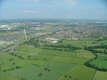
 Lower half of Connah's Quay from the air, with Flintshire Bridge visible |
|
| Connah's Quay shown within Flintshire | |
| Population | 17,500 |
| OS grid reference | SJ295695 |
| Community |
|
| Principal area | |
| Ceremonial county | |
| Country | Wales |
| Sovereign state | United Kingdom |
| Post town | Deeside |
| Postcode district | CH5 |
| Dialling code | 01244 |
| Police | North Wales |
| Fire | North Wales |
| Ambulance | Welsh |
| EU Parliament | Wales |
| UK Parliament | |
| Welsh Assembly | |
Connah's Quay (Welsh: Cei Connah) is a community and the largest town in Flintshire, lying within the Deeside conurbation along the River Dee, near the border with England. It is located 6 miles (9.7 km) west of Chester and can be reached by road from the A548, by rail from the nearby Shotton railway station, and also is on the National Cycle Network Route 5. It is also lies just south of Deeside Industrial Park, one of the largest such complexes in the region. The major part of Tata steelworks is also on the town's border on the north bank of the River Dee. Wepre Woods, an ancient woodland in the town, is controlled by Flintshire County Council's Ranger Service and includes Ewloe Castle which dates from the 13th century.
With a population of approximately 23,000 with Shotton which it is contiguous with, Connah's Quay constitutes just under half of the population of the greater Deeside area.
The original name of the place was New Quay, but due to confusion with other similarly named places, it was renamed some time after 1860. The town's placename is of uncertain origin; among the theories are:
The earliest recorded settlements date from the time of the Domesday Book, listed as 'Wepre', part of the Hundred of Ati's Cross, Cheshire. The total population was 6 households. Wepre Woods are also recorded, measuring ½ a league.
...
Wikipedia

