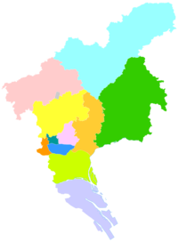
Conghua District
|
Conghua 从化区 |
|
|---|---|
| District | |

Liuxi River in Jiekou Subdistrict
|
|
 Conghua in Guangzhou
|
|
| Coordinates: 23°39′N 113°40′E / 23.650°N 113.667°ECoordinates: 23°39′N 113°40′E / 23.650°N 113.667°E | |
| Country | People's Republic of China |
| Province | Guangdong |
| Sub-provincial city | Guangzhou |
| Area | |
| • Total | 1,974.5 km2 (762.4 sq mi) |
| Population (2006) | |
| • Total | 543,377 |
| • Density | 280/km2 (710/sq mi) |
| Time zone | China Standard (UTC+8) |
| Postal code | 510900 |
| Area code(s) | 020 |
| Website | www |
| Conghua | |||||||||||||||||
| Simplified Chinese | |||||||||||||||||
|---|---|---|---|---|---|---|---|---|---|---|---|---|---|---|---|---|---|
| Traditional Chinese | |||||||||||||||||
| Canton Romanization | Cung4-fa3 | ||||||||||||||||
| Hanyu Pinyin | Cónghuà | ||||||||||||||||
| Postal | Tsungfa | ||||||||||||||||
| Literal meaning | From Change | ||||||||||||||||
|
|||||||||||||||||
| Transcriptions | |
|---|---|
| Standard Mandarin | |
| Hanyu Pinyin | Cónghuà |
| Wade–Giles | Ts‘ung-hua |
| Yue: Cantonese | |
| Yale Romanization | Chùhngfa |
| Jyutping | Cung4-faa3 |
| Canton Romanization | Cung4-fa3 |
Conghua District, formerly romanized as Tsungfa, is an urban district of Guangzhou in central Guangdong, China. Conghua connects the Pearl River Delta with the mountainous area of northern Guangdong. Within China, it is known for its hot springs and lychees. It covers an area of 1,984 km2 (766 sq mi), with a population of 600,000. Its GDP was RMB10.369 billion (US$2,360 per person).
Under the Qing, the area was known as Conghua County. It was subsequently upgraded to county-level city status and then, on 12 February 2014, to an urban district of Guangzhou.
...
Wikipedia
