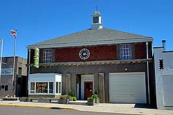
Condon, Oregon
| Condon, Oregon | |
|---|---|
| City | |

Condon City Hall
|
|
 Location in Oregon |
|
| Coordinates: 45°14′8″N 120°11′6″W / 45.23556°N 120.18500°WCoordinates: 45°14′8″N 120°11′6″W / 45.23556°N 120.18500°W | |
| Country | United States |
| State | Oregon |
| County | Gilliam |
| Incorporated | 1893 |
| Government | |
| • Mayor | Jim Hassing |
| Area | |
| • Total | 0.83 sq mi (2.15 km2) |
| • Land | 0.83 sq mi (2.15 km2) |
| • Water | 0 sq mi (0 km2) |
| Elevation | 2,831 ft (863 m) |
| Population (2010) | |
| • Total | 682 |
| • Estimate (2012) | 712 |
| • Density | 821.7/sq mi (317.3/km2) |
| Time zone | Pacific (UTC-8) |
| • Summer (DST) | Pacific (UTC-7) |
| ZIP code | 97823 |
| Area code(s) | 458 and 541 |
| FIPS code | 41-15000 |
| GNIS feature ID | 1119195 |
| Website | |
|
Condon Commercial Historic District
|
|

The IOOF Hall, J.F. Reisacher Building, and Bank Block (left to right) in 2012.
|
|
| Location | Downtown Condon, Oregon |
| Area | 9.95 acres (4.03 ha) |
| NRHP Reference # |
98000609 (original) 01000493 (increase) |
| Significant dates | |
| Added to NRHP | May 29, 1998 |
| Boundary increase | May 16, 2001 |
Condon is a city in, and the county seat of, Gilliam County, in the U.S. state of Oregon. The population was 682 at the 2010 census. The city, with an historic main street along Oregon Route 19, is a farming and ranching community.
Condon was the southern terminus of the Condon Branch of the Union Pacific Railroad. In 1883, a local homesteader named Potter platted the land around a spring on his property. The spring, which emerged from a bed of black basalt, was known to pioneer ranchers in the area as Summit Springs. Experiencing financial difficulty, Potter surrendered the site to the legal firm Condon and Cornish from Arlington. Harvey C. Condon, a member of the firm, was a nephew of Oregon geologist Thomas Condon. Condon and Cornish sold lots in the townsite and in 1884, resident David B. Trimble applied for a post office and became its first postmaster. He named the post office Condon after Harvey C. Condon.
Condon Air Force Station was a radar station near the city that operated from 1951 to 1970.
In 1998, Condon's historic downtown core along Main Street was listed on the National Register of Historic Places as the Condon Commercial Historic District. The City of Condon is collaborating with business interests to "spruce up" buildings on Main Street. Most of the businesses on the Historic Main Street have been restored, new businesses have opened, a new library has been built, the City Park has been re-designed and the Chamber of Commerce is growing.
Condon, in Gilliam County in north-central Oregon, is at the intersection of Oregon Route 19, running north–south through the city, and Oregon Route 206, which runs east–west at Condon. By highway, the city is 38 miles (61 km) south of Interstate 84 at Arlington, 69 miles (111 km) southeast of The Dalles, and 150 miles (240 km) east of Portland.
...
Wikipedia
